IMAGES TAKEN NEAR TO
Killinghall Road, BRADFORD, BD3 8DS
Introduction
This page details the photographs taken nearby to Killinghall Road, BD3 8DS by members of the Geograph project.
The Geograph project started in 2005 with the aim of publishing, organising and preserving representative images for every square kilometre of Great Britain, Ireland and the Isle of Man.

There are currently over 7.5m images from over14,400 individuals and you can help contribute to the project by visiting https://www.geograph.org.uk
Image Map (Loading...)


Getting Data...Please wait
Leaflet Map data © OpenStreetMap
Images are licensed for reuse under creativecommons.org/licenses/by-sa/2.0
Notes
- Clicking on the map will re-center to the selected point.
- The higher the marker number, the further away the image location is from the centre of the postcode.
Image Listing (267 Images Found)
Images are licensed for reuse under creativecommons.org/licenses/by-sa/2.0
Image
Details
Distance
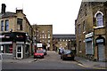
5
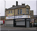
The Charity Shop - Killinghall Road
Image: © Betty Longbottom
Taken: 22 Oct 2009
0.02 miles
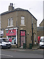
6
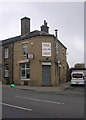
Barrett Fisheries - Killinghall Road
Image: © Betty Longbottom
Taken: 22 Oct 2009
0.03 miles
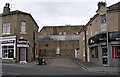
7
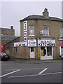
Avanti Kitchens - Killinghall Road
Image: © Betty Longbottom
Taken: 22 Oct 2009
0.03 miles
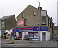
8
Euro Fried Chicken - Killinghall Road
Image: © Betty Longbottom
Taken: 22 Oct 2009
0.04 miles
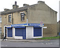
9
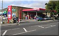
Murco Filling Station - Killinghall Road
Image: © Betty Longbottom
Taken: 12 Oct 2008
0.04 miles
10
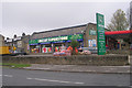
Watan Superstore - Rochester Street
Image: © Betty Longbottom
Taken: 22 Oct 2009
0.04 miles