IMAGES TAKEN NEAR TO
Upper Rushton Road, BRADFORD, BD3 7LQ
Introduction
This page details the photographs taken nearby to Upper Rushton Road, BD3 7LQ by members of the Geograph project.
The Geograph project started in 2005 with the aim of publishing, organising and preserving representative images for every square kilometre of Great Britain, Ireland and the Isle of Man.

There are currently over 7.5m images from over14,400 individuals and you can help contribute to the project by visiting https://www.geograph.org.uk
Image Map (Loading...)


Getting Data...Please wait
Leaflet Map data © OpenStreetMap
Images are licensed for reuse under creativecommons.org/licenses/by-sa/2.0
Notes
- Clicking on the map will re-center to the selected point.
- The higher the marker number, the further away the image location is from the centre of the postcode.
Image Listing (95 Images Found)
Images are licensed for reuse under creativecommons.org/licenses/by-sa/2.0
Image
Details
Distance
2
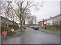
Moorgarth Avenue - Newlands Avenue
Image: © Betty Longbottom
Taken: 13 Dec 2010
0.01 miles
3

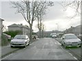
Gloucester Avenue - Upper Rushton Road
Image: © Betty Longbottom
Taken: 23 Oct 2008
0.03 miles
4
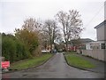
Moorthorpe Avenue - Upper Rushton Road
Image: © Betty Longbottom
Taken: 23 Oct 2008
0.05 miles
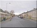
6

Moorlands Avenue - Upper Rushton Road
Image: © Betty Longbottom
Taken: 23 Oct 2008
0.07 miles
8
Upper Rushton Road - viewed from Palin Avenue
Image: © Betty Longbottom
Taken: 13 Dec 2010
0.08 miles
9
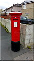
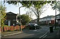
George V Postbox, Palin Avenue / Upper Rushton Road, Bradford
Postbox No. BD3 311, looking like it's recently had a fresh coat of paint.
Image: © Stephen Armstrong
Taken: 25 Apr 2022
0.08 miles
10
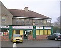
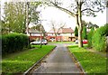
Mortimer House Children's Centre - Mortimer Avenue
Image: © Betty Longbottom
Taken: 13 Dec 2010
0.09 miles