IMAGES TAKEN NEAR TO
Killinghall Road, BRADFORD, BD3 7JD
Introduction
This page details the photographs taken nearby to Killinghall Road, BD3 7JD by members of the Geograph project.
The Geograph project started in 2005 with the aim of publishing, organising and preserving representative images for every square kilometre of Great Britain, Ireland and the Isle of Man.

There are currently over 7.5m images from over14,400 individuals and you can help contribute to the project by visiting https://www.geograph.org.uk
Image Map (Loading...)


Getting Data...Please wait
Leaflet Map data © OpenStreetMap
Images are licensed for reuse under creativecommons.org/licenses/by-sa/2.0
Notes
- Clicking on the map will re-center to the selected point.
- The higher the marker number, the further away the image location is from the centre of the postcode.
Image Listing (136 Images Found)
Images are licensed for reuse under creativecommons.org/licenses/by-sa/2.0
Image
Details
Distance
1
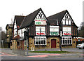
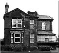
Barrack Tavern
Now an Asian restaurant
Image: © Betty Longbottom
Taken: 10 Mar 2007
0.01 miles
2
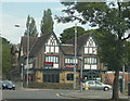
Habib's Restaurant, formerly Ye Barrack Tavern, Bradford Moor
Thornbury Barracks after which this former pub was originally named, stood opposite on what is now a small estate of 1930s semi-detached houses.
Image: © Linden Milner
Taken: 10 Jul 2015
0.01 miles
3
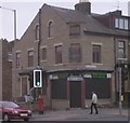
Amnah Textiles & Tailors - Killinghall Road
Image: © Betty Longbottom
Taken: 22 Oct 2009
0.02 miles
4
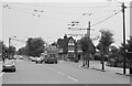
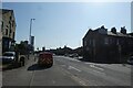
Killinghall Road at Leeds Old Road ? 1971
The distinctive mock-tudor roadhouse pub, Ye Barrack Tavern, has like many such establishments, become an Asian restaurant.
The picture was taken on the final day of trolleybus operation on the Bolton Road group of services. By this time the wiring on Killinghall Road was only used by vehicles making their way to and from Thornbury depot. Trolleybus 723 is one of 20 Karrier W vehicles new in 1946 and rebodied by East Lancs in 1958-59.
This is one of a series of views featuring buses in the 60s, 70s, and 80s. https://www.geograph.org.uk/search.php?i=2114547&displayclass=slide
Image: © Alan Murray-Rust
Taken: 30 Jun 1971
0.02 miles
6
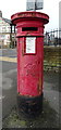
Victorian postbox on Killinghall Road, Bradford
Outside the former Post Office.
Postbox No. BD3 173.
See Image] for context.
Image: © JThomas
Taken: 14 Feb 2020
0.03 miles
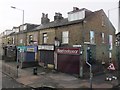
7
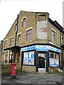
Shop on Killinghall Road, Bradford
The former Post Office.
Showing position of Postbox No. BD3 173.
See Image] for postbox.
Image: © JThomas
Taken: 14 Feb 2020
0.03 miles
8
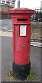
Victorian Post Box - Junction of Barkerend Road & Killinghall Road
Image: © Betty Longbottom
Taken: 30 Apr 2018
0.04 miles
9
Post van on Barkerend Road
The van is on part of CS1, the Leeds-Bradford cycle superhighway.
Image: © DS Pugh
Taken: 26 May 2023
0.04 miles
10
Closed shops on Killinghall Road
Naz Footwear and Textiles, and Ali Textiles, were all shut on a Saturday morning, as indeed they were when photographed on a Thursday in 2009 Image Image Image So maybe they had not been trading for a considerable time.
Taken from the top of a 670 bus to Bradford.
Image: © Stephen Craven
Taken: 16 Jan 2016
0.04 miles