IMAGES TAKEN NEAR TO
Moorcroft Avenue, BRADFORD, BD3 7HW
Introduction
This page details the photographs taken nearby to Moorcroft Avenue, BD3 7HW by members of the Geograph project.
The Geograph project started in 2005 with the aim of publishing, organising and preserving representative images for every square kilometre of Great Britain, Ireland and the Isle of Man.

There are currently over 7.5m images from over14,400 individuals and you can help contribute to the project by visiting https://www.geograph.org.uk
Image Map
Images are licensed for reuse under creativecommons.org/licenses/by-sa/2.0
Notes
- Clicking on the map will re-center to the selected point.
- The higher the marker number, the further away the image location is from the centre of the postcode.
Image Listing (149 Images Found)
Images are licensed for reuse under creativecommons.org/licenses/by-sa/2.0
Image
Details
Distance
2
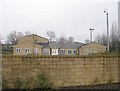
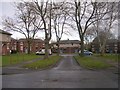
Thornbury Medical Centre - off Rushton Avenue - Front View
Image: © Betty Longbottom
Taken: 12 Feb 2011
0.03 miles
3
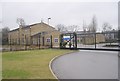
Thornbury Medical Centre - off Rushton Avenue - Side View
Image: © Betty Longbottom
Taken: 12 Feb 2011
0.03 miles
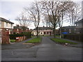
4
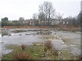
Derelict Land - off Rushton Avenue
Image: © Betty Longbottom
Taken: 12 Feb 2011
0.05 miles
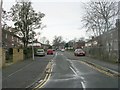
6
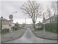
Moorfield Avenue - Elsworth Avenue
Image: © Betty Longbottom
Taken: 13 Dec 2010
0.07 miles
7
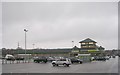
Early one Morning! - Morrisons Car Park - viewed from Rushton Avenue
Image: © Betty Longbottom
Taken: 12 Feb 2011
0.08 miles
9

Addison Avenue - Upper Rushton Road
Image: © Betty Longbottom
Taken: 23 Oct 2008
0.09 miles