IMAGES TAKEN NEAR TO
Calverley Avenue, BRADFORD, BD3 7HT
Introduction
This page details the photographs taken nearby to Calverley Avenue, BD3 7HT by members of the Geograph project.
The Geograph project started in 2005 with the aim of publishing, organising and preserving representative images for every square kilometre of Great Britain, Ireland and the Isle of Man.

There are currently over 7.5m images from over14,400 individuals and you can help contribute to the project by visiting https://www.geograph.org.uk
Image Map
Images are licensed for reuse under creativecommons.org/licenses/by-sa/2.0
Notes
- Clicking on the map will re-center to the selected point.
- The higher the marker number, the further away the image location is from the centre of the postcode.
Image Listing (206 Images Found)
Images are licensed for reuse under creativecommons.org/licenses/by-sa/2.0
Image
Details
Distance
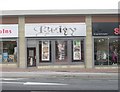
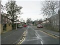
3
Bradford Plaza - Rushton Avenue
This consists of a number of small units, mainly dress & material shops, catering for the Asian community.
Image: © Betty Longbottom
Taken: 13 Apr 2014
0.04 miles
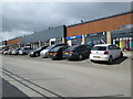
6
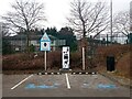
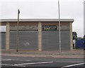
E. V. Charging Point in Morrison's Carpark, Thornbury, Bradford
Image: © Stephen Armstrong
Taken: 27 Feb 2024
0.05 miles
7
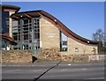
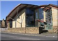
Thornbury Library - Leeds Old Road
Image: © Betty Longbottom
Taken: 17 Feb 2008
0.05 miles
9
St Margaret's Church - Leeds Old Road
Image: © Betty Longbottom
Taken: 17 Feb 2008
0.06 miles
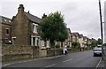
10
Knightsbridge Kitchens - Leeds Old Road
Image: © Betty Longbottom
Taken: 27 Sep 2010
0.06 miles