IMAGES TAKEN NEAR TO
Knightsway Court, BRADFORD, BD3 7DE
Introduction
This page details the photographs taken nearby to Knightsway Court, BD3 7DE by members of the Geograph project.
The Geograph project started in 2005 with the aim of publishing, organising and preserving representative images for every square kilometre of Great Britain, Ireland and the Isle of Man.

There are currently over 7.5m images from over14,400 individuals and you can help contribute to the project by visiting https://www.geograph.org.uk
Image Map (Loading...)


Getting Data...Please wait
Leaflet Map data © OpenStreetMap
Images are licensed for reuse under creativecommons.org/licenses/by-sa/2.0
Notes
- Clicking on the map will re-center to the selected point.
- The higher the marker number, the further away the image location is from the centre of the postcode.
Image Listing (158 Images Found)
Images are licensed for reuse under creativecommons.org/licenses/by-sa/2.0
Image
Details
Distance
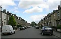
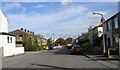
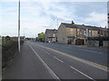
2
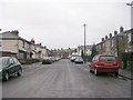
Woodhall Place - looking towards Woodhall Avenue
Image: © Betty Longbottom
Taken: 12 Feb 2011
0.03 miles
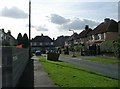
3
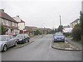
Woodhall View - looking towards Gain Lane
Image: © Betty Longbottom
Taken: 12 Feb 2011
0.04 miles
7
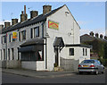
Golden Palace Chinese Restaurant - Woodhall Avenue
Image: © Betty Longbottom
Taken: 4 Oct 2009
0.05 miles
9
Gain Lane cycleway
A 1.3km spur off the main Bradford to Leeds Cycle Superhighway.
Image: © Stephen Craven
Taken: 13 May 2017
0.06 miles
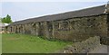
10
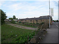
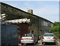
Gain Lane Farm
A working farm on the urban fringe of Bradford. The farm buildings are listed grade 2 (list entry 1135122).
Image: © Stephen Craven
Taken: 13 May 2017
0.06 miles