IMAGES TAKEN NEAR TO
Otley Road, BRADFORD, BD3 0EY
Introduction
This page details the photographs taken nearby to Otley Road, BD3 0EY by members of the Geograph project.
The Geograph project started in 2005 with the aim of publishing, organising and preserving representative images for every square kilometre of Great Britain, Ireland and the Isle of Man.

There are currently over 7.5m images from over14,400 individuals and you can help contribute to the project by visiting https://www.geograph.org.uk
Image Map (Loading...)


Getting Data...Please wait
Leaflet Map data © OpenStreetMap
Images are licensed for reuse under creativecommons.org/licenses/by-sa/2.0
Notes
- Clicking on the map will re-center to the selected point.
- The higher the marker number, the further away the image location is from the centre of the postcode.
Image Listing (232 Images Found)
Images are licensed for reuse under creativecommons.org/licenses/by-sa/2.0
Image
Details
Distance
1
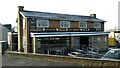
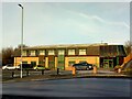
The Airedale, Otley Road / North Wing, Bradford
Built in the early 1960s on a site a little further back than the original Airedale Inn, to allow for the car park. Information taken from the Bradford Telegraph & Argus website https://www.thetelegraphandargus.co.uk/tahistory/15636458.bradford-pub-inspired-affection/
Image: © Stephen Armstrong
Taken: 16 Dec 2022
0.00 miles
2
RAOB Club & Institute - North Wing
Image: © Betty Longbottom
Taken: 18 Oct 2007
0.01 miles
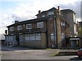
5
J. H. Clissold, Oldgate Mill, North Wing, Bradford
High quality cloth manufacturers since 1910, originally based in Cleckheaton. Re-located to Bradford in 1961 & into the current modern premises in the early 1980s. The mill is located behind the office frontage.
Image: © Stephen Armstrong
Taken: 16 Dec 2022
0.04 miles
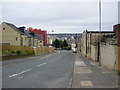
6
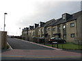
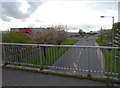
Ariba Avenue
Part of a recent new development built on the site of former council flats between Otley Road & North Wing.
Image: © Stephen Armstrong
Taken: 19 Jun 2010
0.04 miles
7
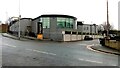
Mashriq, New Otley Road, Bradford
A wedding / banqueting venue. The building was built in the 1960s/70s as the City Band Club, minus the curved structure, which I believe is the banqueting hall. After a period of closure in the 2000s, it became the Sunrise Restaurant & in recent months Mashriq. I live a short distance away and, as I write this, there are very loud fireworks indicating a wedding celebration is in progress. This is the rear, seen from Otley Road. See also Image
Image: © Stephen Armstrong
Taken: 22 Dec 2022
0.04 miles
8
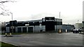
Mashriq & Barbecue Garden, New Otley Road, Bradford
Mashriq is a wedding / banqueting venue, and Barbecue Garden is restaurant. The building was built in the 1960s/70s as the City Band Club. After a period of closure in the 2000s, it became the Sunrise Restaurant & in recent months Mashriq.
Image: © Stephen Armstrong
Taken: 22 Dec 2022
0.04 miles
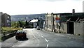
10
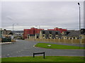
Otley Road, Bradford BD3
The bottom end of Otley Road, with new build and refurbishment everywhere. About 50 yards down the road you're in SE1633.
Image: © Stephen Armstrong
Taken: 6 Sep 2009
0.06 miles