IMAGES TAKEN NEAR TO
Otley Road, BRADFORD, BD3 0EH
Introduction
This page details the photographs taken nearby to Otley Road, BD3 0EH by members of the Geograph project.
The Geograph project started in 2005 with the aim of publishing, organising and preserving representative images for every square kilometre of Great Britain, Ireland and the Isle of Man.

There are currently over 7.5m images from over14,400 individuals and you can help contribute to the project by visiting https://www.geograph.org.uk
Image Map (Loading...)


Getting Data...Please wait
Leaflet Map data © OpenStreetMap
Images are licensed for reuse under creativecommons.org/licenses/by-sa/2.0
Notes
- Clicking on the map will re-center to the selected point.
- The higher the marker number, the further away the image location is from the centre of the postcode.
Image Listing (207 Images Found)
Images are licensed for reuse under creativecommons.org/licenses/by-sa/2.0
Image
Details
Distance
2
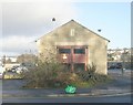
Electricity Substation 48975 - Otley Road Apartments
Image: © Betty Longbottom
Taken: 18 Jan 2011
0.02 miles
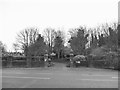
4
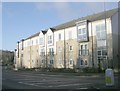
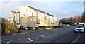
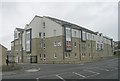
Otley Road Apartments - opposite Undercliffe Cemetery
Image: © Betty Longbottom
Taken: 18 Jan 2011
0.05 miles
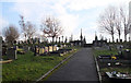
7
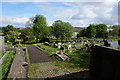
Undercliffe Cemetery, Bradford
Taken from Otley Road.
Image: © Stephen Armstrong
Taken: 20 Nov 2021
0.06 miles
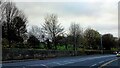
9
Entrance to Undercliffe Cemetery, Otley Road
The cemetery is a local authority one, including a consecrated area. See also Image
Image: © Stephen Craven
Taken: 30 Nov 2019
0.07 miles
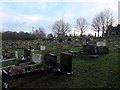
10
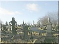
Undercliffe Cemetery - Otley Road
Image: © Betty Longbottom
Taken: 18 Jan 2011
0.07 miles