IMAGES TAKEN NEAR TO
Southey Place, BRADFORD, BD3 0AA
Introduction
This page details the photographs taken nearby to Southey Place, BD3 0AA by members of the Geograph project.
The Geograph project started in 2005 with the aim of publishing, organising and preserving representative images for every square kilometre of Great Britain, Ireland and the Isle of Man.

There are currently over 7.5m images from over14,400 individuals and you can help contribute to the project by visiting https://www.geograph.org.uk
Image Map
Images are licensed for reuse under creativecommons.org/licenses/by-sa/2.0
Notes
- Clicking on the map will re-center to the selected point.
- The higher the marker number, the further away the image location is from the centre of the postcode.
Image Listing (216 Images Found)
Images are licensed for reuse under creativecommons.org/licenses/by-sa/2.0
Image
Details
Distance
1
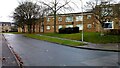
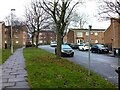
Avenham Way, Pollard Park, Bradford
Pollard Park is a social housing estate of mainly flats, built in the late 1970s. Some of the properties are away from the road and only accessible from a footpath. I used to deliver parcels in this area so I knew my way around, but for anyone not familiar with the area the numbering of properties can be confusing.
Image: © Stephen Armstrong
Taken: 22 Dec 2022
0.01 miles
4
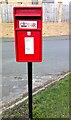
Queen Elizabeth II Postbox BD3 30, Brookfield Road, Bradford
Image: © Stephen Armstrong
Taken: 23 Feb 2023
0.03 miles
5

Snow Covered Remains of Milton House, New Otley Road, Bradford
Milton House was a relatively modern council run care home and day centre for the elderly - now it's just a pile of crushed rubble. Many of the residents were moved to the nearby, newly built Dove Court, run by Hanover Housing.
Image: © Stephen Armstrong
Taken: 6 Jan 2010
0.03 miles
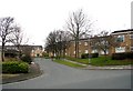
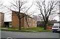
6
Brookfield Road, Pollard Park, Bradford
Pollard Park is a social housing estate built in the late 1970s. The only vehicular access into the estate is via Brookfield Road, but there are several paths from various points surrounding the estate.
Image: © Stephen Armstrong
Taken: 22 Dec 2022
0.03 miles
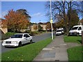
8
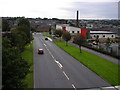
New Otley Road
From the Greenway Bridge looking down towards Barkerend Road. The new building is the Hillside Bridge Health Centre. A walk-in Health Centre & Pharmacy, open 8.00am to 8.00pm every day of the year, including Christmas Day. Notice the red car braking for the Speed Camera.
Image: © Stephen Armstrong
Taken: 6 Sep 2009
0.04 miles

10
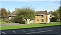
Milton House - New Otley Road
Former residential centre for the elderly.
Image: © Betty Longbottom
Taken: 18 Oct 2007
0.05 miles