IMAGES TAKEN NEAR TO
Myers Lane, BRADFORD, BD2 4ES
Introduction
This page details the photographs taken nearby to Myers Lane, BD2 4ES by members of the Geograph project.
The Geograph project started in 2005 with the aim of publishing, organising and preserving representative images for every square kilometre of Great Britain, Ireland and the Isle of Man.

There are currently over 7.5m images from over14,400 individuals and you can help contribute to the project by visiting https://www.geograph.org.uk
Image Map (Loading...)


Getting Data...Please wait
Leaflet Map data © OpenStreetMap
Images are licensed for reuse under creativecommons.org/licenses/by-sa/2.0
Notes
- Clicking on the map will re-center to the selected point.
- The higher the marker number, the further away the image location is from the centre of the postcode.
Image Listing (95 Images Found)
Images are licensed for reuse under creativecommons.org/licenses/by-sa/2.0
Image
Details
Distance
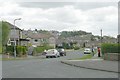
1
St Francis' Catholic Primary School - Myers Lane
Image: © Betty Longbottom
Taken: 2 May 2009
0.02 miles
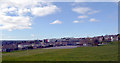
2
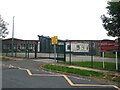
St. Francis Catholic Primary School, Myers Lane, Bradford
Image: © Stephen Armstrong
Taken: 17 Sep 2023
0.02 miles
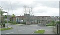
4
St. Francis Catholic Primary School
The school is seen from Bolton Road (A6176). The large white building behind it is Hanson Academy.
Image: © habiloid
Taken: 6 Apr 2020
0.05 miles