IMAGES TAKEN NEAR TO
Stainforth Road, SETTLE, BD24 9NP
Introduction
This page details the photographs taken nearby to Stainforth Road, BD24 9NP by members of the Geograph project.
The Geograph project started in 2005 with the aim of publishing, organising and preserving representative images for every square kilometre of Great Britain, Ireland and the Isle of Man.

There are currently over 7.5m images from over14,400 individuals and you can help contribute to the project by visiting https://www.geograph.org.uk
Image Map (Loading...)


Getting Data...Please wait
Leaflet Map data © OpenStreetMap
Images are licensed for reuse under creativecommons.org/licenses/by-sa/2.0
Notes
- Clicking on the map will re-center to the selected point.
- The higher the marker number, the further away the image location is from the centre of the postcode.
Image Listing (44 Images Found)
Images are licensed for reuse under creativecommons.org/licenses/by-sa/2.0
Image
Details
Distance
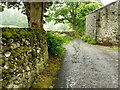
1
Field Systems
The wonderful stonewalls on the hillside between Stainforth (left) and Langcliffe (right).
Image: © William Bartlett
Taken: 31 Dec 2005
0.06 miles
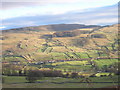
2
B6479 entering the Yorkshire Dales National Park
Looking north to Stainforth quarries and Stainforth Scar
Image: © David Smith
Taken: 3 Oct 2016
0.07 miles
4
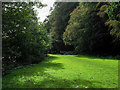
Along the Dales High Way
A walking party heading towards Settle on water-saturated ground alongside the River Ribble which is raging beyond the trees on the left side of the image.
Image: © Trevor Littlewood
Taken: 28 Sep 2019
0.15 miles
5
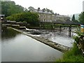
The weir over the Ribble near Stackhouse
Image: © Andy Jamieson
Taken: 17 Jun 2009
0.15 miles
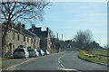
7
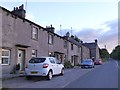
Terraced houses by B6479 north of Langcliffe
This terrace lies between the village and the mill
Image: © David Smith
Taken: 6 Oct 2016
0.16 miles
9
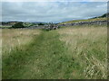
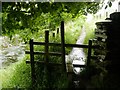
Langcliffe to Stainforth footpath
On the east side of Ribblesdale. This path is shown on the large-scale OS map surveyed in 1847.
Image: © Christine Johnstone
Taken: 24 Jun 2023
0.16 miles