IMAGES TAKEN NEAR TO
Market Place, SETTLE, BD24 9EN
Introduction
This page details the photographs taken nearby to Market Place, BD24 9EN by members of the Geograph project.
The Geograph project started in 2005 with the aim of publishing, organising and preserving representative images for every square kilometre of Great Britain, Ireland and the Isle of Man.

There are currently over 7.5m images from over14,400 individuals and you can help contribute to the project by visiting https://www.geograph.org.uk
Image Map
Images are licensed for reuse under creativecommons.org/licenses/by-sa/2.0
Notes
- Clicking on the map will re-center to the selected point.
- The higher the marker number, the further away the image location is from the centre of the postcode.
Image Listing (711 Images Found)
Images are licensed for reuse under creativecommons.org/licenses/by-sa/2.0
Image
Details
Distance
1
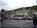
Settle, Yorkshire
View east from the Market Square
Image: © Dr Neil Clifton
Taken: 11 May 2007
0.00 miles
2
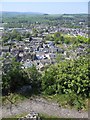
View from Castlebergh, Settle to Giggleswick
The view from Castlebergh flagpole across Settle towards Giggleswick School. Everything this side of the prominent town hall, and the market square next to it, is in SD8263. In the distance the dome of Giggleswick School Chapel is just visible in the centre of the photo below the clump of trees on the horizon.
Image: © John S Turner
Taken: 1 May 2007
0.01 miles
3
Settle from Castlebergh Viewpoint
Looking down on Settle from Castlebergh where the English flag flies - see Image The Town Hall, which is just into the next square, can be seen with its plentiful array of chimneys in the centre of the photo. To the right of the Town Hall the regular Tuesday market is taking place. All the buildings on this side of the Town Hall are in this square.
Image: © John S Turner
Taken: 1 May 2007
0.01 miles
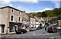
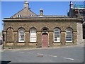
4
Lloyds TSB, Settle
The front of the Lloyds TSB bank building faces on to Market Place, Settle. To the right of the building is High Street. Castlebergh crag and its flag can be seen above the bank. For a side view of the bank see Image .
Image: © John S Turner
Taken: 1 May 2007
0.01 miles
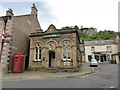
5
Lloyds TSB, Settle
The side view of the Lloyds TSB building as seen from High Street,Settle. The front entrance of the bank is around the corner on the left on Market Place. Castle Hill is just to the right of the building - see Image
Image: © John S Turner
Taken: 1 May 2007
0.01 miles
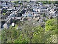
6
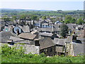
Settle Roofscape from Castlebergh
Below the huge limestone cliff of Castlebergh there is a large flat area, with the remains of a seat, from where you can look out over the roofs of Settle. The array of chimneys on the town hall are clearly visible, and all the buildings nearer than that are in this grid square. The dome of Giggleswick School chapel can be seen in front of the clump of trees on the horizon.
Image: © John S Turner
Taken: 1 May 2007
0.01 miles
8
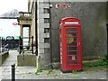
Converted telephone box, Cheapside
Decommissioned phone box which now contains a defibrillator.
This is a K6 type kiosk, designed in 1935 by Sir Giles Gilbert Scott, and is a listed building https://historicengland.org.uk/listing/the-list/list-entry/1316712 .
Image: © Rose and Trev Clough
Taken: 19 May 2017
0.01 miles
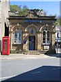
9
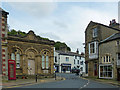
Former bank, Market Place, Settle
This was Lloyds Bank http://www.geograph.org.uk/photo/4687018 .
The plaque below the right hand window commemorates the founder of the Royal Society for the Protection of Cruelty to Children http://www.geograph.org.uk/photo/1754674
The following shared description in provided by N Chadwick.
Image: © Robin Drayton
Taken: 19 Sep 2018
0.01 miles