IMAGES TAKEN NEAR TO
Mill Close, SETTLE, BD24 9BX
Introduction
This page details the photographs taken nearby to Mill Close, BD24 9BX by members of the Geograph project.
The Geograph project started in 2005 with the aim of publishing, organising and preserving representative images for every square kilometre of Great Britain, Ireland and the Isle of Man.

There are currently over 7.5m images from over14,400 individuals and you can help contribute to the project by visiting https://www.geograph.org.uk
Image Map
Images are licensed for reuse under creativecommons.org/licenses/by-sa/2.0
Notes
- Clicking on the map will re-center to the selected point.
- The higher the marker number, the further away the image location is from the centre of the postcode.
Image Listing (295 Images Found)
Images are licensed for reuse under creativecommons.org/licenses/by-sa/2.0
Image
Details
Distance
1
Disused highways depot
Located in King's Mill Lane. Former North Yorkshire County Council area depot, with partially demolished building.
Image: © Rose and Trev Clough
Taken: 19 May 2017
0.03 miles
2
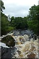
River Ribble
Up stream of Giggleswick Memorial Bridge
Image: © Alexander P Kapp
Taken: 10 Apr 2010
0.03 miles
3
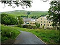
Footpath at Giggleswick overlooking Settle
Image: © Andy Jamieson
Taken: 15 Jun 2009
0.04 miles
4
River Ribble near Kings Mill Lane, Settle
Image: © Alexander P Kapp
Taken: 16 Jul 2010
0.04 miles
5
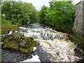
Upstream along the Ribble
Looking along the River Ribble in Settle.
Image: © DS Pugh
Taken: 6 Jul 2020
0.05 miles
6
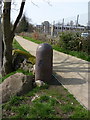
Bollard on the edge of Riverside Walk
Image: © Alexander P Kapp
Taken: 10 Apr 2010
0.05 miles
7
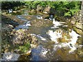
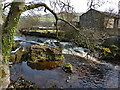
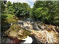
Queen's Rock
The River Ribble looking upstream from Giggleswick Memorial Bridge, with the river rushing over rocks after a placid stretch. Apparently this was once "King's Rock", according to http://www.archive.org/stream/churchwardensofg00brayiala/churchwardensofg00brayiala_djvu.txt (1884) , which also comments that it "is rapidly breaking
up", so it was presumably more of a rock-like feature.
Image: © Derek Harper
Taken: 29 Jun 2006
0.05 miles
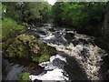
8
The Queen's Rock, River Ribble, Settle
This rock in the river lies on the South Craven Fault. To the north the rocks are limestone, to the south millstone grit.
Image: © David Smith
Taken: 3 Oct 2016
0.05 miles
9
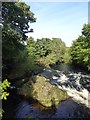
River Ribble upstream of Giggleswick Memorial Footbridge
Even in relatively low flow conditions the river is very turbid and coloured with peat from the moors to the east of Ribblesdale.
Image: © Stephen Craven
Taken: 19 Jul 2020
0.05 miles
10
River Ribble at Giggleswick
From Giggleswick Memorial Footbridge.
Image: © philandju
Taken: 9 Sep 2012
0.05 miles