IMAGES TAKEN NEAR TO
Selside, SETTLE, BD24 0HU
Introduction
This page details the photographs taken nearby to BD24 0HU by members of the Geograph project.
The Geograph project started in 2005 with the aim of publishing, organising and preserving representative images for every square kilometre of Great Britain, Ireland and the Isle of Man.

There are currently over 7.5m images from over14,400 individuals and you can help contribute to the project by visiting https://www.geograph.org.uk
Image Map
Images are licensed for reuse under creativecommons.org/licenses/by-sa/2.0
Notes
- Clicking on the map will re-center to the selected point.
- The higher the marker number, the further away the image location is from the centre of the postcode.
Image Listing (8 Images Found)
Images are licensed for reuse under creativecommons.org/licenses/by-sa/2.0
Image
Details
Distance
1
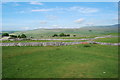
Looking towards South House from Over Pasture
The quality of the fields improves as you near the steading.
Image: © John Haynes
Taken: 29 Jun 2010
0.02 miles
2
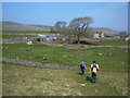
South House, Sulber
Looking north towards the farm on a path unmarked on the OS maps. Park Fell (563m) is on the skyline at right of shot.
Image: © michael ely
Taken: 12 May 2006
0.02 miles
3
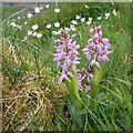
Rose-pink form of Early Purple Orchid (Orchis mascula)
The usual dark purple Early Purple Orchid was numerous at Brae Pasture Nature Reserve but these 3 spikes of a pale rose-pink form were found. The out-of-focus white flowers are Wood Anemone.
Image: © Greg Fitchett
Taken: 8 May 2018
0.16 miles
4

Brae Pasture Nature Reserve
This small area of rough grassland and some limestone pavement was strewn with Wood Anemone, Primrose and Early Purple Orchid during my visit. Pen-y-ghent looms across the valley of Ribblesdale. The reserve is owned by the Yorkshire Wildlife Trust.
Image: © Greg Fitchett
Taken: 8 May 2018
0.17 miles
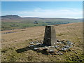
5
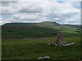
Summit Area of Sulber with Trig Point
The grass covered area at the summit of Sulber has a trig point and minor exposures of limestone pavement of which there is much more nearby. In the distance is the peak of Pen-y-ghent.
Image: © Trevor Littlewood
Taken: 12 Jun 2010
0.20 miles
7
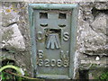
Ordnance Survey Flush Bracket G2085
This bracket can be found on Stone House Barn.
For more detail see : http://www.bench-marks.org.uk/bm11841
Image: © Peter Wood
Taken: 30 Jun 2012
0.21 miles
8
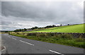
Field barn beside the B6479
Unlike many, this one is not named on the 1907 25-inch OS map.
Image: © Bill Harrison
Taken: 6 Aug 2019
0.22 miles