IMAGES TAKEN NEAR TO
Giggleswick, SETTLE, BD24 0DE
Introduction
This page details the photographs taken nearby to BD24 0DE by members of the Geograph project.
The Geograph project started in 2005 with the aim of publishing, organising and preserving representative images for every square kilometre of Great Britain, Ireland and the Isle of Man.

There are currently over 7.5m images from over14,400 individuals and you can help contribute to the project by visiting https://www.geograph.org.uk
Image Map
Images are licensed for reuse under creativecommons.org/licenses/by-sa/2.0
Notes
- Clicking on the map will re-center to the selected point.
- The higher the marker number, the further away the image location is from the centre of the postcode.
Image Listing (232 Images Found)
Images are licensed for reuse under creativecommons.org/licenses/by-sa/2.0
Image
Details
Distance
1
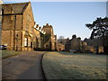
Holywell Toft
The Headmaster's considerable house at Giggleswick school. The lawn in front of the house shows signs of the site of an old wall when dried out.
Image: © William Bartlett
Taken: 3 Sep 2005
0.01 miles
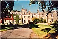
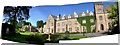
2
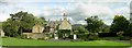
Giggleswick School Dining Hall
The long building lower centre is the new dining hall and the building to the right is Holywell Toft the Headmaster's house. St Peter's Church and the village are seen beyond and in the distance the hills above Settle and the Ribble Valley
Image: © William Bartlett
Taken: 10 Feb 2006
0.01 miles
3
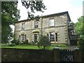
Howsons, Giggleswick
One of the old houses that has become part of Giggleswick School. The narrow entrance bay breaks forward a little and is emphasised by quoins. The windows show a feature popular around here: the central lintel of three rests on top of the outer lintels.
Image: © Humphrey Bolton
Taken: 7 Aug 2008
0.01 miles
4
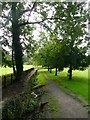
Public footpath across the grounds of Giggleswick School
This runs towards the church, which is probably the reason that it came into use. It is along the edge of a playing field, and there is a ditch alongside.
Image: © Humphrey Bolton
Taken: 7 Aug 2008
0.01 miles
5
Giggleswick School from below The Flat
The Flat is a quadrangle surrounded by buildings on three sides. The open part is bounded by the driveway seen here heading towards Nowell and Paley House.
Image: © Chris Heaton
Taken: 19 Feb 2008
0.02 miles
6
Giggleswick School
Giggleswick School, Settle.
Image: © Alan Hughes
Taken: 30 May 1995
0.03 miles
7
Gordon's Caf? At Giggleswick School
Marhof annual Marilyn baggers' dinner was based at Giggleswick School this year. Many of our group had two nights boarding in Nowell Boarding House. Others slept in their camper vans in the visitors' car park. This picture records a view across the car park where Gordon Adshead has set up a breakfast table before 07:30.
Image: © Rude Health
Taken: 31 Aug 2013
0.04 miles

9
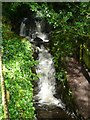
Waterfall in the grounds of Giggleswick School
The Tems Beck flows through the school grounds, and there is a series of waterfalls. This one can be seen from the public footpath that goes from Mill Hill Lane across the back of Catteral House to the old Kendal road.
Image: © Humphrey Bolton
Taken: 7 Aug 2008
0.06 miles
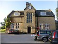
10
Giggleswick School
The main entrance door to the school is shown. The main building is the school hostel block containing the Sharpe Library and three boys boarding houses and the administrative block. To the far left of the photograph is the main teaching block and "the flat". The photograph is taken from next to Headmaster's House (Holywell Toft).
Image: © William Bartlett
Taken: 2 Jun 2004
0.06 miles