IMAGES TAKEN NEAR TO
Thorpe, SKIPTON, BD23 5HN
Introduction
This page details the photographs taken nearby to BD23 5HN by members of the Geograph project.
The Geograph project started in 2005 with the aim of publishing, organising and preserving representative images for every square kilometre of Great Britain, Ireland and the Isle of Man.

There are currently over 7.5m images from over14,400 individuals and you can help contribute to the project by visiting https://www.geograph.org.uk
Image Map
Images are licensed for reuse under creativecommons.org/licenses/by-sa/2.0
Notes
- Clicking on the map will re-center to the selected point.
- The higher the marker number, the further away the image location is from the centre of the postcode.
Image Listing (13 Images Found)
Images are licensed for reuse under creativecommons.org/licenses/by-sa/2.0
Image
Details
Distance
1
Langerton House Farm
Farming operation offering bed and breakfast off Thorpe Lane
Image: © Chris Heaton
Taken: 5 Mar 2021
0.01 miles
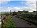
2
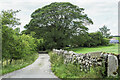
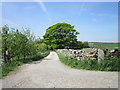
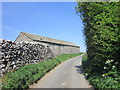
Access road for Langerton Farm
The farm road leaves Thorpe Lane, a minor road connecting the villages at Thorpe and Cracoe.
Image: © Trevor Littlewood
Taken: 9 Jul 2023
0.05 miles
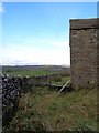
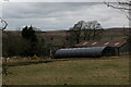
9
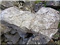
Crinoidal Limestone
Crinoidal debris, possibly from part of the apron reef.
Image: © Ashley Dace
Taken: 9 Oct 2017
0.17 miles