IMAGES TAKEN NEAR TO
Old Mill Lane, SKIPTON, BD23 5BX
Introduction
This page details the photographs taken nearby to Old Mill Lane, BD23 5BX by members of the Geograph project.
The Geograph project started in 2005 with the aim of publishing, organising and preserving representative images for every square kilometre of Great Britain, Ireland and the Isle of Man.

There are currently over 7.5m images from over14,400 individuals and you can help contribute to the project by visiting https://www.geograph.org.uk
Image Map
Images are licensed for reuse under creativecommons.org/licenses/by-sa/2.0
Notes
- Clicking on the map will re-center to the selected point.
- The higher the marker number, the further away the image location is from the centre of the postcode.
Image Listing (211 Images Found)
Images are licensed for reuse under creativecommons.org/licenses/by-sa/2.0
Image
Details
Distance
1
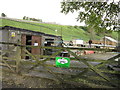
The Dales Way
#217, buildings next to Brow Well Fisheries.
Image: © Ian S
Taken: 19 Oct 2012
0.01 miles
2
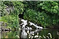
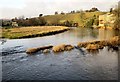
Grassington: Mini waterfall flowing into the River Wharfe
Image: © Michael Garlick
Taken: 30 Jul 2019
0.01 miles
4
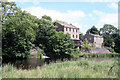
Houses on the River Wharfe
Below Grassington, on the route of the Dales Way Path.
Image: © Peter Barr
Taken: 8 Sep 2013
0.02 miles
6
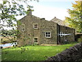
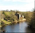
River Wharfe at Low Mill
From the same point as Image], looking to the right (upstream), with overlap. On the left is St Michael & All Angels Church http://list.english-heritage.org.uk/resultsingle.aspx?uid=1167172&searchtype=mapsearch , on the right Low Mill House and cottages.
Image: © Derek Harper
Taken: 29 Dec 2013
0.04 miles
7

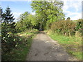
Dales Way trek from Bolton Abbey to Pinder Stile (143)
Looking towards the fish farm
Image: © Basher Eyre
Taken: 13 Sep 2014
0.04 miles
8
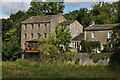
Low Mill, Grassington
Old OS 6" maps of the late 19thC show this as a worsted mill, whereas Linton Mill, a few hundred metres upstream was a cotton mill. Both mill complexes have now been converted into dwellings.
Image: © Gordon Hatton
Taken: 11 Nov 2017
0.04 miles
9
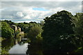
View over the Wharfe from Linton Churchyard
Image: © Dr Neil Clifton
Taken: 30 Jun 2008
0.04 miles
10
The Dales Way
#216, heading towards Brow Well Fisheries.
Image: © Ian S
Taken: 19 Oct 2012
0.04 miles