IMAGES TAKEN NEAR TO
Coniston Cold, SKIPTON, BD23 4EQ
Introduction
This page details the photographs taken nearby to BD23 4EQ by members of the Geograph project.
The Geograph project started in 2005 with the aim of publishing, organising and preserving representative images for every square kilometre of Great Britain, Ireland and the Isle of Man.

There are currently over 7.5m images from over14,400 individuals and you can help contribute to the project by visiting https://www.geograph.org.uk
Image Map
Images are licensed for reuse under creativecommons.org/licenses/by-sa/2.0
Notes
- Clicking on the map will re-center to the selected point.
- The higher the marker number, the further away the image location is from the centre of the postcode.
Image Listing (5 Images Found)
Images are licensed for reuse under creativecommons.org/licenses/by-sa/2.0
Image
Details
Distance
1
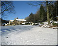
Stainton Cotes in Winter
Large residence on Moorber Lane - access is challenging in conditions such as this.
Image: © Chris Heaton
Taken: 8 Dec 2010
0.14 miles
2
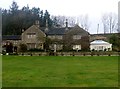
Stainton Cotes
One of the post houses at the hamlet of Stainton Cotes accessed via a track from Coniston Cold.
Image: © Rude Health
Taken: 9 Dec 2013
0.15 miles
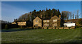
4
Stainton Cotes
The house and farmhouse (left) are Grade II Listed Buildings - see https://historicengland.org.uk/listing/the-list/list-entry/1296778 & https://historicengland.org.uk/listing/the-list/list-entry/1167683
Image: © Ian Taylor
Taken: 14 Nov 2018
0.16 miles
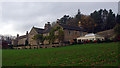
5
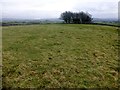
Winterley Cobba
Parked in Coniston Cold and walked up to Pot Haw Farm with easy access to the summit through fields with a course set out for horses. Then through similar fields to bag Winterley Cobba. Then joined the bridleway below Stainton Cotes to get back to Coniston Cold. A lovely area to explore even with Martin Richardson.
Name: Winterley Cobba
Hill number: 108476
Height: 220m / 722ft
Area: 36: Lancashire, Cheshire & the Southern Pennines
Class: 2
Grid ref: SD887541 (est)
Drop: 37m
Col: 183m SD887543
Image: © Rude Health
Taken: 9 Dec 2013
0.25 miles