IMAGES TAKEN NEAR TO
Gisburn Road, SKIPTON, BD23 3UA
Introduction
This page details the photographs taken nearby to Gisburn Road, BD23 3UA by members of the Geograph project.
The Geograph project started in 2005 with the aim of publishing, organising and preserving representative images for every square kilometre of Great Britain, Ireland and the Isle of Man.

There are currently over 7.5m images from over14,400 individuals and you can help contribute to the project by visiting https://www.geograph.org.uk
Image Map
Images are licensed for reuse under creativecommons.org/licenses/by-sa/2.0
Notes
- Clicking on the map will re-center to the selected point.
- The higher the marker number, the further away the image location is from the centre of the postcode.
Image Listing (40 Images Found)
Images are licensed for reuse under creativecommons.org/licenses/by-sa/2.0
Image
Details
Distance
3
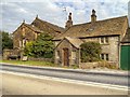
Victorian Buildings at West Marton
Another view of the two buildings shown in Image The smaller one, nearest to the camera, carries the initials RFR and the date 1889 on the lintel over the doorway. The other, larger building, behind it has the same initials and the date 1884, together with a sword, on the gable end Image
Image: © David Dixon
Taken: 26 Jul 2014
0.02 miles
4
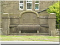
Jubilee Trough, West Marton
This stone trough at the side of the A59, near the West Marton crossroads, carries the following inscription:
H.J.R. 1887
BEING THE FIFTIETH YEAR
OF THE REIGN OF
QUEEN VICTORIA
Image: © David Dixon
Taken: 26 Jul 2014
0.02 miles
6
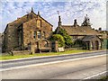
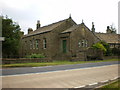
West Marton
Two interesting buildings on the A59, Gisburn Road at the West Marton crossroads. The larger building, nearest to the corner has the initials RFR and the date 1884 together with a sword carved on the stonework on the gable end (Image]). The other, smaller building has the same initials and the date 1889 on the lintel above the doorway. I'm not sure what their original purpose was, but the larger one *may* have been the village institute http://oneguyfrombarlick.co.uk/viewtopic.php?f=360&t=9071 .
The stone trough is dated 1887 to commemorate Queen Victoria's golden jubilee year.
Image: © David Dixon
Taken: 26 Jul 2014
0.02 miles
7
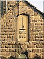
RFR 1884
Inscription on the stonework of the gable end of the larger building in
Image
Image: © David Dixon
Taken: 26 Jul 2014
0.02 miles
8
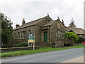
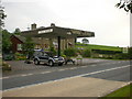
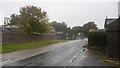
Old Building, New Use at junction of A59 and Gledstone Road in West Marton
Viewed from the north-east.
Image: © Peter Wood
Taken: 30 May 2014
0.03 miles
10
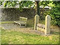
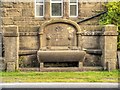
Stocks and Seat, West Morton
At the side of Gledstone Road.
Image: © David Dixon
Taken: 26 Jul 2014
0.04 miles