IMAGES TAKEN NEAR TO
Flasby, SKIPTON, BD23 3PX
Introduction
This page details the photographs taken nearby to BD23 3PX by members of the Geograph project.
The Geograph project started in 2005 with the aim of publishing, organising and preserving representative images for every square kilometre of Great Britain, Ireland and the Isle of Man.

There are currently over 7.5m images from over14,400 individuals and you can help contribute to the project by visiting https://www.geograph.org.uk
Image Map
Images are licensed for reuse under creativecommons.org/licenses/by-sa/2.0
Notes
- Clicking on the map will re-center to the selected point.
- The higher the marker number, the further away the image location is from the centre of the postcode.
Image Listing (32 Images Found)
Images are licensed for reuse under creativecommons.org/licenses/by-sa/2.0
Image
Details
Distance
1
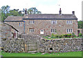
House in Flasby
A fine, solid house in the village.
Image: © John Illingworth
Taken: 14 May 2008
0.04 miles
2
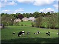
Flasby
Looking west towards the hamlet from the opposite side of the beck
Image: © Chris Heaton
Taken: 23 May 2006
0.05 miles
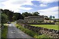
3
The hamlet of Flasby
Just a few houses and farmsteads.
Image: © philandju
Taken: 30 Jul 2015
0.05 miles
4
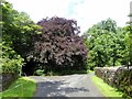
Road junction in Flasby
The splendid copper beech stands at the joining of the ingress and exit roads to the hamlet. Both roads are one-way.
Image: © philandju
Taken: 30 Jul 2015
0.05 miles
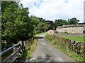
5
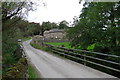
Grange Farm, Flasby
Looking across the bridge over Flasby Beck
Image: © Tim Heaton
Taken: 13 Oct 2013
0.05 miles
7
![A circular walk via Sharp Haw and Flasby [33]](https://s0.geograph.org.uk/geophotos/07/00/50/7005076_604ef00b_120x120.jpg)
A circular walk via Sharp Haw and Flasby [33]
Grange Farmhouse was built in the mid 18th century incorporating an earlier structure, with alterations in both the 19th and 20th centuries. Constructed of squared rubble stone under a stone slate roof. The extension to the left is early 19th century. Listed, grade II, with details at: https://historicengland.org.uk/listing/the-list/list-entry/1317081
Starting from the wonderfully named Bog Lane, near Tarn House, the walk follows the long distance Dales High Way. The route ascends to Sharp Haw then on via Flasby Fell to the village of Flasby. The return is mostly through woodland – High Wood and Crag Side Wood. About 5¾ miles.
Image: © Michael Dibb
Taken: 18 Jun 2021
0.06 miles
8
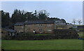
Grange Farm, Flasby
Farming operation based in the hamlet of Flasby
Image: © Chris Heaton
Taken: 27 Jan 2021
0.06 miles
9
![A circular walk via Sharp Haw and Flasby [35]](https://s2.geograph.org.uk/geophotos/07/00/50/7005078_8308423c_120x120.jpg)
A circular walk via Sharp Haw and Flasby [35]
The building of Flasby Hall Farm, seen from the track, a public footpath.
Starting from the wonderfully named Bog Lane, near Tarn House, the walk follows the long distance Dales High Way. The route ascends to Sharp Haw then on via Flasby Fell to the village of Flasby. The return is mostly through woodland – High Wood and Crag Side Wood. About 5¾ miles.
Image: © Michael Dibb
Taken: 18 Jun 2021
0.06 miles
10
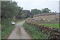
In Flasby
If you are hill bagging from Flasby there appears to be limited parking here. Space for two cars.
Image: © Michael Graham
Taken: 21 Sep 2016
0.06 miles