IMAGES TAKEN NEAR TO
Stirton, SKIPTON, BD23 3LH
Introduction
This page details the photographs taken nearby to BD23 3LH by members of the Geograph project.
The Geograph project started in 2005 with the aim of publishing, organising and preserving representative images for every square kilometre of Great Britain, Ireland and the Isle of Man.

There are currently over 7.5m images from over14,400 individuals and you can help contribute to the project by visiting https://www.geograph.org.uk
Image Map
Images are licensed for reuse under creativecommons.org/licenses/by-sa/2.0
Notes
- Clicking on the map will re-center to the selected point.
- The higher the marker number, the further away the image location is from the centre of the postcode.
Image Listing (21 Images Found)
Images are licensed for reuse under creativecommons.org/licenses/by-sa/2.0
Image
Details
Distance
1
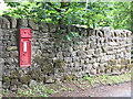
Victorian postbox in Stirton
Set into the wall of Sour Lane.
Image: © Stephen Craven
Taken: 22 Jun 2009
0.01 miles
2
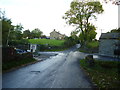
Stirton: Crossroads
Stirton is a tiny village or hamlet north of the A65. It is so small that it does not even have its own Parish Council, but shares with Thorlby, another small village just a short distance west. There is not much to Stirton apart from the crossroads shown here.
Image: © Dr Neil Clifton
Taken: 4 Oct 2014
0.01 miles
3
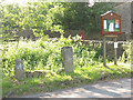
Village stocks, Stirton
Disused stocks on the corner of Stirton Lane and White Hills Lane, alongside a much more recent community notice board.
Image: © Stephen Craven
Taken: 19 Jun 2009
0.02 miles
4
The Village Stocks, Stirton
Located at the crossroads in the small village of Stirton - where Stirton Lane, Sour Lane, Bog Lane and White Hills Lane meet.
Sadly no longer in use, but remains a monument to the past.
Image: © Chris Heaton
Taken: 22 Nov 2020
0.02 miles
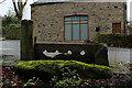
5
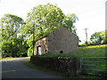
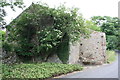
Barn at the centre of Stirton
This stone barn is at the crossroads of Stirton Lane and White Hills Lane.
Image: © Stephen Craven
Taken: 19 Jun 2009
0.03 miles
6
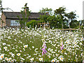
Late spring flowers on Bog Lane
The daisies and emerging foxgloves make a colourful scene in front of an old house.
Image: © Stephen Craven
Taken: 19 Jun 2009
0.06 miles
7
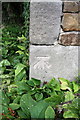
Benchmark on barn, Bog Lane
Ordnance Survey cut mark benchmark described on the Bench Mark Database at http://www.bench-marks.org.uk/bm46980
Image: © Roger Templeman
Taken: 15 Jul 2013
0.08 miles
8
Ordnance Survey Cut Mark
This mark can be found on the wall of a barn in Bog Lane, Stirton.
For more detail see : http://www.bench-marks.org.uk/bm46980
Image: © Peter Wood
Taken: 25 Jan 2013
0.08 miles
9
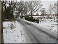
Bog Lane, Stirton
Looking north-east up Bog Lane which runs from the A65 road to the B6265. The picture was taken from the barn on the western side of the lane.
Image: © Peter Wood
Taken: 25 Jan 2013
0.08 miles
10
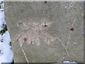
Barn on NW side of Bog Lane
There is an OS benchmark Image on the road face of the near corner of the barn
Image: © Roger Templeman
Taken: 15 Jul 2013
0.08 miles