IMAGES TAKEN NEAR TO
Neville Street, SKIPTON, BD23 2EU
Introduction
This page details the photographs taken nearby to Neville Street, BD23 2EU by members of the Geograph project.
The Geograph project started in 2005 with the aim of publishing, organising and preserving representative images for every square kilometre of Great Britain, Ireland and the Isle of Man.

There are currently over 7.5m images from over14,400 individuals and you can help contribute to the project by visiting https://www.geograph.org.uk
Image Map (Loading...)


Getting Data...Please wait
Leaflet Map data © OpenStreetMap
Images are licensed for reuse under creativecommons.org/licenses/by-sa/2.0
Notes
- Clicking on the map will re-center to the selected point.
- The higher the marker number, the further away the image location is from the centre of the postcode.
Image Listing (720 Images Found)
Images are licensed for reuse under creativecommons.org/licenses/by-sa/2.0
Image
Details
Distance
1
![Skipton houses [5]](https://s0.geograph.org.uk/geophotos/07/01/61/7016188_228d92fb_120x120.jpg)
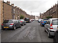
Skipton houses [5]
Middletown is a suburb of Skipton. It consists of long terraces of cottages. This view is of Neville Street.
Skipton is a market town in North Yorkshire, some 27 miles northwest of Leeds. On the southern edge of the Yorkshire Dales National Park, it is now an important tourist destination. The town expanded after the construction of Skipton Castle in the 11th century. The Leeds and Liverpool Canal runs through the town and the River Aire flows just to the southwest. The name Skipton means 'sheep-town'.
Image: © Michael Dibb
Taken: 21 Jun 2021
0.01 miles
2
![Skipton ways [7]](https://s1.geograph.org.uk/geophotos/07/01/61/7016189_bb8a6af0_120x120.jpg)
Skipton ways [7]
Middletown is a suburb of Skipton. It consists of long terraces of cottages with, between the terraces, rear alleyways. This view is of the rear alley between Neville Street and Devonshire Street. It would seem that this is the day on which the rubbish bins are due to be emptied.
Skipton is a market town in North Yorkshire, some 27 miles northwest of Leeds. On the southern edge of the Yorkshire Dales National Park, it is now an important tourist destination. The town expanded after the construction of Skipton Castle in the 11th century. The Leeds and Liverpool Canal runs through the town and the River Aire flows just to the southwest. The name Skipton means 'sheep-town'.
Image: © Michael Dibb
Taken: 21 Jun 2021
0.03 miles
3
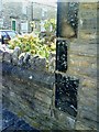
Neville Street benchmark
Side wall of #2 Neville Street. There is an Ordnance Survey cut mark benchmark on the 6th stone course above the side road surface, about 1 ft from the junction of the front garden wall and the house itself. More information on this mark can be found on the Bench Mark Database at http://www.bench-marks.org.uk/bm34808
Image: © Roger Templeman
Taken: 5 Jul 2010
0.03 miles
4
![Skipton features [21]](https://s2.geograph.org.uk/geophotos/07/01/61/7016190_e675c514_120x120.jpg)
Skipton features [21]
Seen in the alleyway between Neville Street and Devonshire Street is this coal store cover. In the days of coal heating, the coal delivery would be poured through the opening in the coal store (better known in Yorkshire as the "coal 'ole").
Skipton is a market town in North Yorkshire, some 27 miles northwest of Leeds. On the southern edge of the Yorkshire Dales National Park, it is now an important tourist destination. The town expanded after the construction of Skipton Castle in the 11th century. The Leeds and Liverpool Canal runs through the town and the River Aire flows just to the southwest. The name Skipton means 'sheep-town'.
Image: © Michael Dibb
Taken: 25 Jun 2021
0.04 miles
5
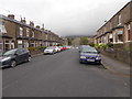
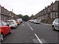
Devonshire Street - viewed from Wellington Street
Image: © Betty Longbottom
Taken: 31 Aug 2016
0.05 miles
7
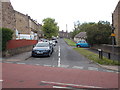
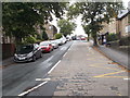
Wellington Street - Devonshire Street
Image: © Betty Longbottom
Taken: 31 Aug 2016
0.05 miles
9
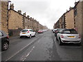
Devonshire Street - Brougham Street
Image: © Betty Longbottom
Taken: 31 Aug 2016
0.06 miles
10
Brougham Street - viewed from Devonshire Street
Image: © Betty Longbottom
Taken: 31 Aug 2016
0.06 miles