IMAGES TAKEN NEAR TO
Lumb Lane, KEIGHLEY, BD22 0NF
Introduction
This page details the photographs taken nearby to Lumb Lane, BD22 0NF by members of the Geograph project.
The Geograph project started in 2005 with the aim of publishing, organising and preserving representative images for every square kilometre of Great Britain, Ireland and the Isle of Man.

There are currently over 7.5m images from over14,400 individuals and you can help contribute to the project by visiting https://www.geograph.org.uk
Image Map
Images are licensed for reuse under creativecommons.org/licenses/by-sa/2.0
Notes
- Clicking on the map will re-center to the selected point.
- The higher the marker number, the further away the image location is from the centre of the postcode.
Image Listing (7 Images Found)
Images are licensed for reuse under creativecommons.org/licenses/by-sa/2.0
Image
Details
Distance
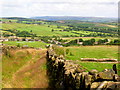
2
Descent towards Ickornshaw
The Pennine Way is approaching Lower Summer House Farm visible ahead.
Image: © Bill Boaden
Taken: 11 Apr 2015
0.15 miles
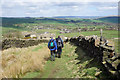
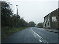
3
Pennine Way approaching Lower Summer House Farm
Image: © John Slater
Taken: 14 Jan 2014
0.15 miles
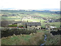
4
Ickornshaw from the Pennine Way
Looking northeast from approx. SD965428. Cowling church (SD968431) is in the background.
Image: © Dave Dunford
Taken: 19 May 2005
0.21 miles
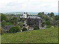
6
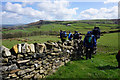
Stile crossing near Lower Summer House Farm
A new wall has appeared which is not on most maps. Prominent on the far side of the valley is Earl Crag.
Image: © Bill Boaden
Taken: 11 Apr 2015
0.22 miles
7
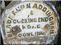
Milestone before rejuvenation by Moonrakers
The milestones around the village have now been cleaned and painted by Cowling's Moonraker group.
Image: © Ken Edgar
Taken: 21 May 2006
0.23 miles