IMAGES TAKEN NEAR TO
Kingsway, BRADFORD, BD2 1PN
Introduction
This page details the photographs taken nearby to Kingsway, BD2 1PN by members of the Geograph project.
The Geograph project started in 2005 with the aim of publishing, organising and preserving representative images for every square kilometre of Great Britain, Ireland and the Isle of Man.

There are currently over 7.5m images from over14,400 individuals and you can help contribute to the project by visiting https://www.geograph.org.uk
Image Map
Images are licensed for reuse under creativecommons.org/licenses/by-sa/2.0
Notes
- Clicking on the map will re-center to the selected point.
- The higher the marker number, the further away the image location is from the centre of the postcode.
Image Listing (91 Images Found)
Images are licensed for reuse under creativecommons.org/licenses/by-sa/2.0
Image
Details
Distance
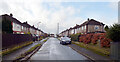

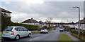
3
Knigsway, Plumpton Park, BD2
Looking north-westward.
Image: © Peter Wood
Taken: 5 May 2016
0.06 miles
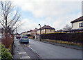
5
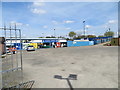
Eccleshill United Play Here
Looking north-westward from the car park.
Image: © Peter Wood
Taken: 5 May 2016
0.08 miles


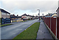
10
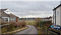
Alley off Westfield Lane, Bradford
Eccleshill United's football ground is in the distance.
Image: © habiloid
Taken: 15 Feb 2021
0.10 miles