IMAGES TAKEN NEAR TO
Plumpton Mead, BRADFORD, BD2 1NF
Introduction
This page details the photographs taken nearby to Plumpton Mead, BD2 1NF by members of the Geograph project.
The Geograph project started in 2005 with the aim of publishing, organising and preserving representative images for every square kilometre of Great Britain, Ireland and the Isle of Man.

There are currently over 7.5m images from over14,400 individuals and you can help contribute to the project by visiting https://www.geograph.org.uk
Image Map (Loading...)


Getting Data...Please wait
Leaflet Map data © OpenStreetMap
Images are licensed for reuse under creativecommons.org/licenses/by-sa/2.0
Notes
- Clicking on the map will re-center to the selected point.
- The higher the marker number, the further away the image location is from the centre of the postcode.
Image Listing (72 Images Found)
Images are licensed for reuse under creativecommons.org/licenses/by-sa/2.0
Image
Details
Distance
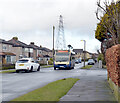
1
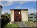
Electricity Substation No 681 - Plumpton Mead
Image: © Betty Longbottom
Taken: 11 May 2011
0.04 miles

5
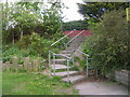
Steps - from Kings Road to All Alone Lane
Image: © Betty Longbottom
Taken: 28 Apr 2011
0.05 miles
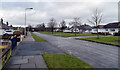
6
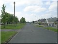
Kings Road - looking towards Wrose Road
Image: © Betty Longbottom
Taken: 28 Apr 2011
0.05 miles

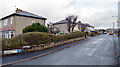
9
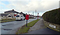
Kingsway, Bradford
Kingsway seen from its junction with Kings Road. A close up of the post box can be seen in Image
Image: © habiloid
Taken: 15 Feb 2021
0.08 miles