IMAGES TAKEN NEAR TO
Spring Avenue, KEIGHLEY, BD21 4UW
Introduction
This page details the photographs taken nearby to Spring Avenue, BD21 4UW by members of the Geograph project.
The Geograph project started in 2005 with the aim of publishing, organising and preserving representative images for every square kilometre of Great Britain, Ireland and the Isle of Man.

There are currently over 7.5m images from over14,400 individuals and you can help contribute to the project by visiting https://www.geograph.org.uk
Image Map
Images are licensed for reuse under creativecommons.org/licenses/by-sa/2.0
Notes
- Clicking on the map will re-center to the selected point.
- The higher the marker number, the further away the image location is from the centre of the postcode.
Image Listing (75 Images Found)
Images are licensed for reuse under creativecommons.org/licenses/by-sa/2.0
Image
Details
Distance
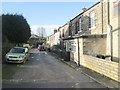
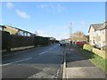
1
Spring Avenue - viewed from Spring Drive
Image: © Betty Longbottom
Taken: 1 Feb 2014
0.02 miles
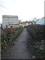
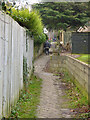
2
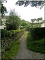
Footpath - Spring Avenue, Thwaites Brow
Image: © Betty Longbottom
Taken: 23 Sep 2008
0.02 miles
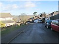
7
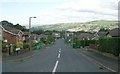
Dale View Grove - Spring Drive, Thwaites Brow
Image: © Betty Longbottom
Taken: 23 Sep 2008
0.06 miles
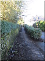
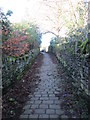
8
Footpath to Thwaites Brow (6)
A splendid example of a stone-setted footpath from the days of the Industrial Revolution. I presume it was for workers to reach the factories in the town of Keighley (and at another time maybe for quarry workers living in the valley bottom to reach the quarries higher up the hill).
At the kink in the track just ahead, the footpath splits - even on the 1852 map, showing just how old this route is. Straight on was to the Long Lee coal pits; left to Royd House (a historic farm) and surrounding quarries.
Image: © Stephen Craven
Taken: 13 Jan 2018
0.07 miles
9
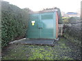
Electricity Substation No 684 - Spring Drive
Image: © Betty Longbottom
Taken: 1 Feb 2014
0.07 miles