IMAGES TAKEN NEAR TO
Royd Ings Avenue, KEIGHLEY, BD21 4BX
Introduction
This page details the photographs taken nearby to Royd Ings Avenue, BD21 4BX by members of the Geograph project.
The Geograph project started in 2005 with the aim of publishing, organising and preserving representative images for every square kilometre of Great Britain, Ireland and the Isle of Man.

There are currently over 7.5m images from over14,400 individuals and you can help contribute to the project by visiting https://www.geograph.org.uk
Image Map (Loading...)


Getting Data...Please wait
Leaflet Map data © OpenStreetMap
Images are licensed for reuse under creativecommons.org/licenses/by-sa/2.0
Notes
- Clicking on the map will re-center to the selected point.
- The higher the marker number, the further away the image location is from the centre of the postcode.
Image Listing (105 Images Found)
Images are licensed for reuse under creativecommons.org/licenses/by-sa/2.0
Image
Details
Distance
2
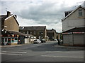
Row of houses on SE side of Bradford Road at Dale Street junction
The nearest house. #271, was a post office and has an Ordnance Survey benchmark Image on the house wall below a former stamp dispensing machine
Image: © Roger Templeman
Taken: 28 Nov 2023
0.07 miles
3
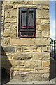
Benchmark on #271 Bradford Road
The Ordnance Survey cut mark benchmark below the stamp dispensers of the former post office is described on the Bench Mark Database at http://www.bench-marks.org.uk/bm43879
Image: © Roger Templeman
Taken: 29 Jun 2012
0.07 miles
4
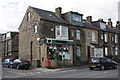
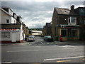
#271 Bradford Road at Dale Street junction
This former post office now a shop selling electrical goods including computers. There is an OS benchmark Image on the side of the building below the stamp vending machines.
Image: © Roger Templeman
Taken: 29 Jun 2012
0.07 miles
5
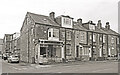
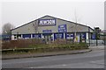
Closed Post Office, Bradford Road
An area of short streets of stone built terraced housing, now with one less local facility.
Image: © Des Blenkinsopp
Taken: 28 Jul 2022
0.07 miles
6
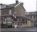
Hair Tec Unisex Hair Studio - Bradford Road
Image: © Betty Longbottom
Taken: 6 Feb 2010
0.07 miles
7
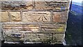
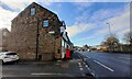
Benchmark on Dale Street face of #271 Bradford Road
Ordnance Survey cut mark benchmark Image levelled at 85.713m above Newlyn Datum verified 1962
Image: © Roger Templeman
Taken: 28 Nov 2023
0.07 miles
8
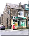
Former Post Office - Bradford Road, Keighley
Image: © Betty Longbottom
Taken: 15 Oct 2008
0.08 miles