IMAGES TAKEN NEAR TO
West Leeds Street, KEIGHLEY, BD21 2NA
Introduction
This page details the photographs taken nearby to West Leeds Street, BD21 2NA by members of the Geograph project.
The Geograph project started in 2005 with the aim of publishing, organising and preserving representative images for every square kilometre of Great Britain, Ireland and the Isle of Man.

There are currently over 7.5m images from over14,400 individuals and you can help contribute to the project by visiting https://www.geograph.org.uk
Image Map
Images are licensed for reuse under creativecommons.org/licenses/by-sa/2.0
Notes
- Clicking on the map will re-center to the selected point.
- The higher the marker number, the further away the image location is from the centre of the postcode.
Image Listing (117 Images Found)
Images are licensed for reuse under creativecommons.org/licenses/by-sa/2.0
Image
Details
Distance
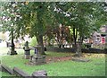
4
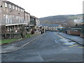
Burial ground, North Dean Road, Keighley
There was no church or chapel adjacent, but there was a Primitive Methodist chapel on West Lane nearby, so I guess it was associated with that.
Image: © Stephen Craven
Taken: 21 Jan 2023
0.03 miles
5
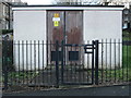
Electricity Substation No 866 - Lustre Street
Image: © Betty Longbottom
Taken: 2 Jan 2015
0.03 miles

8

GR wall postbox, West Lane, Keighley
On the corner of Back Edensor Road.
Image: © Stephen Craven
Taken: 21 Jan 2023
0.04 miles
9
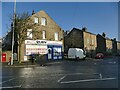
Ruby News, West Lane, Keighley
See Image for a close look at the wall postbox.
Image: © Stephen Craven
Taken: 21 Jan 2023
0.04 miles
10
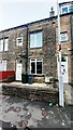
#67 Devonshire Street West
Ordnance Survey documents indicate that a benchmark levelled at 145.225m above Newlyn Datum was verified in 1962 on the front of the house, near where the white utilities cabinet is now mounted.
Image: © Roger Templeman
Taken: 30 Jan 2024
0.05 miles