IMAGES TAKEN NEAR TO
Pear Tree Terrace, KEIGHLEY, BD20 9DQ
Introduction
This page details the photographs taken nearby to Pear Tree Terrace, BD20 9DQ by members of the Geograph project.
The Geograph project started in 2005 with the aim of publishing, organising and preserving representative images for every square kilometre of Great Britain, Ireland and the Isle of Man.

There are currently over 7.5m images from over14,400 individuals and you can help contribute to the project by visiting https://www.geograph.org.uk
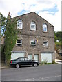
Image Map (Loading...)


Getting Data...Please wait
Leaflet Map data © OpenStreetMap
Images are licensed for reuse under creativecommons.org/licenses/by-sa/2.0
Notes
- Clicking on the map will re-center to the selected point.
- The higher the marker number, the further away the image location is from the centre of the postcode.
Image Listing (101 Images Found)
Images are licensed for reuse under creativecommons.org/licenses/by-sa/2.0
Image
Details
Distance
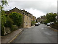
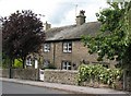
2
Main Street, Low Bradley
A mixture of stone cottages along the original main street of the village. Later Victorian development was mostly lower down the hill near the mill, whilst modern expansion has been beyond the mill to the north west.
Image: © Gordon Hatton
Taken: 13 Jul 2009
0.01 miles
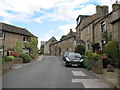
3
Extended houses, Main Street, Low Bradley
On with an attic conversion, one with a porch.
Image: © Christine Johnstone
Taken: 12 Nov 2014
0.02 miles
4
Main Street - viewed from Silsden Road
Image: © Betty Longbottom
Taken: 3 Jun 2016
0.03 miles
6
Box Tree Farm, Low Bradley
Late 18th century building [now two houses] in local stone with attractive sandstone lintels and quoins.
Image: © Gordon Hatton
Taken: 13 Jul 2009
0.03 miles
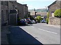
7
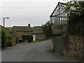
Crag Lane Bottom
View of Crag Lane Bottom at Low Bradley.
Image: © David Rogers
Taken: 9 Jul 2008
0.03 miles
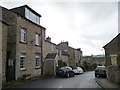
8
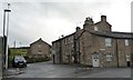
Junction of Silsden Road and Main Street, Low Bradley
Once the centre of the village, now at the eastern edge.
Image: © Christine Johnstone
Taken: 12 Nov 2014
0.03 miles
9
Former chapel, Low Bradley
Built as a Primitive Methodist chapel in 1835. It once had two cottages in the lower part, but the whole building has now been converted for residential use.
Image: © Gordon Hatton
Taken: 13 Jul 2009
0.04 miles
10
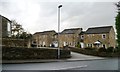
New houses off Lidget Road
A small development near the original centre of Low Bradley.
Image: © Christine Johnstone
Taken: 12 Nov 2014
0.04 miles