IMAGES TAKEN NEAR TO
Ryeland Street, KEIGHLEY, BD20 8SR
Introduction
This page details the photographs taken nearby to Ryeland Street, BD20 8SR by members of the Geograph project.
The Geograph project started in 2005 with the aim of publishing, organising and preserving representative images for every square kilometre of Great Britain, Ireland and the Isle of Man.

There are currently over 7.5m images from over14,400 individuals and you can help contribute to the project by visiting https://www.geograph.org.uk
Image Map
Images are licensed for reuse under creativecommons.org/licenses/by-sa/2.0
Notes
- Clicking on the map will re-center to the selected point.
- The higher the marker number, the further away the image location is from the centre of the postcode.
Image Listing (81 Images Found)
Images are licensed for reuse under creativecommons.org/licenses/by-sa/2.0
Image
Details
Distance
1
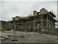
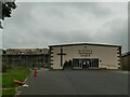
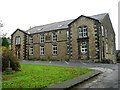
Former Sunday School being converted
Maps up to 1956 show this as a Sunday school, built in 1875 and presumably associated with the adjacent Methodist church. More recent mapping shows this as the church and the original church site as a 'hall'. The original site has more recently returned to worship use but in a new building Image and the old Sunday School now being converted, presumably to apartments. Image shows the building before conversion started.
Image: © Stephen Craven
Taken: 4 Sep 2021
0.04 miles
2
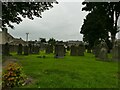
Methodist burial ground in Cross Hills
I assumed this belonged with St Peter's church Image but the 1891 map shows two Methodist chapels close together, each with its own burial ground, and this one seems to belong with St John's (Wesleyan), which was on the site of the present library.
Image: © Stephen Craven
Taken: 4 Sep 2021
0.04 miles
3
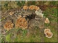
Bracket fungus on a tree stump
The location is in the old Methodist burial ground Image From odd bits of greenery lying around I think this was probably a yew tree, recently felled.
Image: © Stephen Craven
Taken: 4 Sep 2021
0.05 miles
4
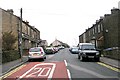
Ryeland Street - Main Street, Cross Hills
Image: © Betty Longbottom
Taken: 28 Oct 2008
0.05 miles
5
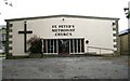
St Peter's Methodist Church, Cross Hills
The 1891 map shows two Methodist chapels close together in Cross Hills, each with its own burial ground - this one, and St John's (Wesleyan). The present church is obviously a modern one built on the site of the original.
Image: © Stephen Craven
Taken: 4 Sep 2021
0.06 miles
6
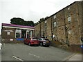
South Craven Community Library, Cross Hills
On the site of a former Wesleyan Methodist chapel.
Image: © Stephen Craven
Taken: 4 Sep 2021
0.06 miles
7
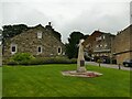
Cross Hills war memorial
In the form of an obelisk set in a lawn on the side of Main Street.
Image: © Stephen Craven
Taken: 4 Sep 2021
0.06 miles
8

St Peter's Methodist Church Graveyard - Main Street
Image: © Betty Longbottom
Taken: 28 Oct 2008
0.06 miles
9
St Peter's Methodist Church - Main Street
Image: © Betty Longbottom
Taken: 28 Oct 2008
0.06 miles
10
United Free Methodist Church Sunday School - Main Street
Built 1875.
Image: © Betty Longbottom
Taken: 28 Oct 2008
0.06 miles