IMAGES TAKEN NEAR TO
Cornerways Gardens, KEIGHLEY, BD20 8QW
Introduction
This page details the photographs taken nearby to Cornerways Gardens, BD20 8QW by members of the Geograph project.
The Geograph project started in 2005 with the aim of publishing, organising and preserving representative images for every square kilometre of Great Britain, Ireland and the Isle of Man.

There are currently over 7.5m images from over14,400 individuals and you can help contribute to the project by visiting https://www.geograph.org.uk
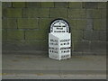
Image Map (Loading...)


Getting Data...Please wait
Leaflet Map data © OpenStreetMap
Images are licensed for reuse under creativecommons.org/licenses/by-sa/2.0
Notes
- Clicking on the map will re-center to the selected point.
- The higher the marker number, the further away the image location is from the centre of the postcode.
Image Listing (40 Images Found)
Images are licensed for reuse under creativecommons.org/licenses/by-sa/2.0
Image
Details
Distance
1
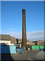
Chimney at Glusburn mill
The magnificent chimney at the once Hayfield woollen mill, now owned by Cirteq, a manufacturer of circlips.
Image: © M T WHITELOCK
Taken: 17 Nov 2007
0.04 miles
2
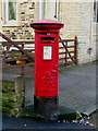
GR VI Pillarbox, Glusburn
Box number BD20 42 at the corner of Croft Head Terrace and Colne Road.
Image: © David Rogers
Taken: 9 Feb 2010
0.04 miles
4
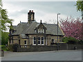
Lodge, Glusburn
Presumably by F.W. Petty, c1890, who designed the industrial village for John Cousen Horsfall. The latter's house, which the lodge served, has gone.
Image: © Stephen Richards
Taken: 17 May 2013
0.05 miles
5
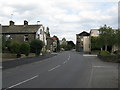
Glusburn: Colne Road, looking east
The A 6068, leading in this direction to Cross Hills.
Image: © Dr Neil Clifton
Taken: 18 Aug 2009
0.05 miles
6
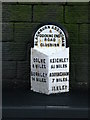
Glusburn Milepost
Beside the A6068 Colne Road in Glusburn.
Image: © David Rogers
Taken: 9 Feb 2010
0.05 miles
7
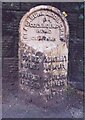
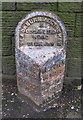
Old Milestone, on the A6068, Colne Road
Glusburn opposite No. 21. Located on the South side of road, on pavement, on slight bend, nearly opp Lodge Street. Metal plate attached to stone post, WR casting design, 19th century. Alternative view see https://www.geograph.org.uk/photo/1702786 (more recently painted)
Inscription reads: COLNE / 8 MILES / BURNLEY / 14 MILES // KEIGHLEY / 5¼ MILES / ADDINGHAM / 7 MILES / ILKLEY / 10¼ / MILES // BLACKBURN ADDINGHAM / & / COCKING END / ROAD / GLUSBURN
Grade II listed by Historic England.
Milestone Society National ID: YN_ADCO07
Image: © Christine Minto
Taken: 16 Dec 2005
0.05 miles
8
Old milestone
This section of the road from Addingham to Blackburn (in Lancashire), is now in North Yorkshire but was, when these milestones were set up in 1893/94 part of the extensive West Riding. The milestone is on the south side of Colne Road in Glusburn. Over the years the pavement has been built up, hiding the mileage to Ilkley which is 10¼ miles. It is painted occasionally.
Image: © Chris Minto
Taken: 29 May 2022
0.06 miles
9
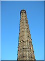
Chimney at Glusburn mill
A closer look at this chimney.
Image: © M T WHITELOCK
Taken: 17 Nov 2007
0.07 miles