Old Milestone, on the A6068, Colne Road
Introduction
The photograph on this page of Old Milestone, on the A6068, Colne Road by Christine Minto as part of the Geograph project.
The Geograph project started in 2005 with the aim of publishing, organising and preserving representative images for every square kilometre of Great Britain, Ireland and the Isle of Man.

There are currently over 7.5m images from over 14,400 individuals and you can help contribute to the project by visiting https://www.geograph.org.uk
Old Milestone, on the A6068, Colne Road
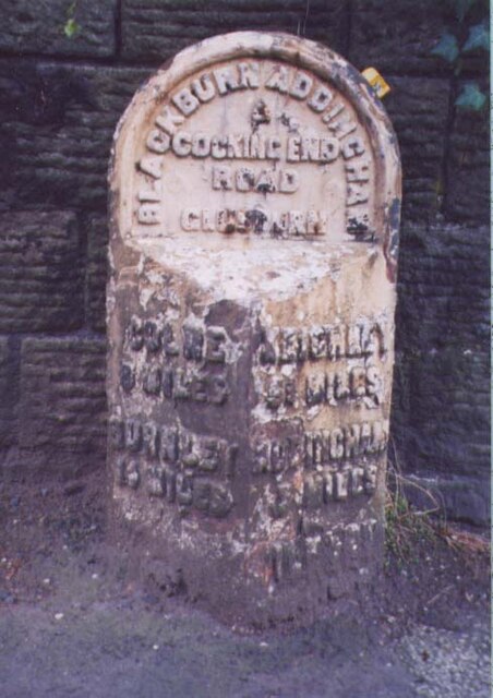
Image: © Christine Minto Taken: 16 Dec 2005
Glusburn opposite No. 21. Located on the South side of road, on pavement, on slight bend, nearly opp Lodge Street. Metal plate attached to stone post, WR casting design, 19th century. Alternative view see https://www.geograph.org.uk/photo/1702786 (more recently painted) Inscription reads: COLNE / 8 MILES / BURNLEY / 14 MILES // KEIGHLEY / 5¼ MILES / ADDINGHAM / 7 MILES / ILKLEY / 10¼ / MILES // BLACKBURN ADDINGHAM / & / COCKING END / ROAD / GLUSBURN Grade II listed by Historic England. Milestone Society National ID: YN_ADCO07
Images are licensed for reuse under creativecommons.org/licenses/by-sa/2.0
Image Location
Latitude
53.898686
Longitude
-2.002429