IMAGES TAKEN NEAR TO
Green Bank, BD20 8FU
Introduction
This page details the photographs taken nearby to Green Bank, BD20 8FU by members of the Geograph project.
The Geograph project started in 2005 with the aim of publishing, organising and preserving representative images for every square kilometre of Great Britain, Ireland and the Isle of Man.

There are currently over 7.5m images from over14,400 individuals and you can help contribute to the project by visiting https://www.geograph.org.uk
Image Map (Loading...)


Getting Data...Please wait
Leaflet Map data © OpenStreetMap
Images are licensed for reuse under creativecommons.org/licenses/by-sa/2.0
Notes
- Clicking on the map will re-center to the selected point.
- The higher the marker number, the further away the image location is from the centre of the postcode.
Image Listing (54 Images Found)
Images are licensed for reuse under creativecommons.org/licenses/by-sa/2.0
Image
Details
Distance

2
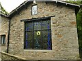
Peacock window at Ryecroft
This is not the main, grade II listed farmhouse (which I didn't photograph as there were children outside) but a building across the lane from it.
Image: © Stephen Craven
Taken: 4 Sep 2021
0.07 miles
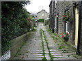
3

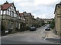
The start of Ryecroft Road
The junction with Green Lane; the group of houses to the left is called Glusburn Green.
Image: © Stephen Craven
Taken: 4 Sep 2021
0.07 miles

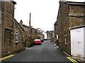
5
Glusburn: Lodge Street
This street is the next one to the west of Hartley Street. It has classic sett paving with a central gutter - well worthy of preservation.
Image: © Dr Neil Clifton
Taken: 18 Aug 2009
0.10 miles
6
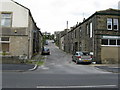
Glusburn: Croft Street
Croft Street leads northwards from the A6068, and is almost exactly on the important 2 degree meridian.
Image: © Dr Neil Clifton
Taken: 18 Aug 2009
0.10 miles
7
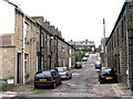
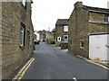
Glusburn: Hartley Street
Northwards of the A6068, this is the next street west of Croft Street.
Image: © Dr Neil Clifton
Taken: 18 Aug 2009
0.10 miles
8
Glusburn: Green Lane
Green Lane rises quite steeply from the A6068 to meet Lothersdale Road, an alternative, much narrower but more scenic, route westwards into Lancashire.
Image: © Dr Neil Clifton
Taken: 18 Aug 2009
0.10 miles