IMAGES TAKEN NEAR TO
Sutton-in-Craven, KEIGHLEY, BD20 7EJ
Introduction
This page details the photographs taken nearby to BD20 7EJ by members of the Geograph project.
The Geograph project started in 2005 with the aim of publishing, organising and preserving representative images for every square kilometre of Great Britain, Ireland and the Isle of Man.

There are currently over 7.5m images from over14,400 individuals and you can help contribute to the project by visiting https://www.geograph.org.uk
Image Map
Images are licensed for reuse under creativecommons.org/licenses/by-sa/2.0
Notes
- Clicking on the map will re-center to the selected point.
- The higher the marker number, the further away the image location is from the centre of the postcode.
Image Listing (26 Images Found)
Images are licensed for reuse under creativecommons.org/licenses/by-sa/2.0
Image
Details
Distance
1
High Jackfield Farm
A 17th century farmhouse and barn, listed grade II (list entry 1166543).
Image: © Stephen Craven
Taken: 21 Jan 2023
0.01 miles
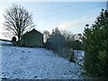
2
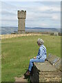
View north from the top of Lund's Tower
Looking towards High Jack Field.
Image: © Christine Johnstone
Taken: 1 Mar 2014
0.10 miles
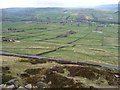
4
Disused Quarry below Lund's Tower
Track from Dick Lane leads through this abandoned quarry to climb up to the folly of Lund's Tower on Earl Crag
Image: © Chris Heaton
Taken: 13 Jul 2011
0.22 miles
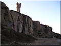
5
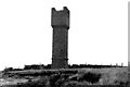
Ethel's Tower
Ethel's Tower, also known as Lund's Tower, was built in 1897 by a local man, James Lund, as a present to his beloved daughter Ethel on her 21st birthday. It has been stated elsewhere that Lund built it to commemorate the Queen's Diamond Jubilee, but remembering that Lund was a Yorkshireman, I will leave the reader to decide which story s/he thinks is the more likely.
Image: © Dr Neil Clifton
Taken: 28 Jul 1987
0.23 miles
6
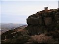
Old Quarry and Lund's Tower
Old sandstone quarry at the eastern end of Earl Crag. Lund's Tower stands on the crest of the hill.
Image: © Gordon Hatton
Taken: 1 Feb 2010
0.23 miles
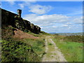
7
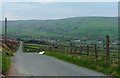
Dick Lane near Cowling (1)
Descending from Earl Crag towards the village.
Image: © Stephen Richards
Taken: 17 May 2013
0.23 miles
8
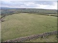
View east from the top of Lund's Tower
Farmland on the south side of Dick Lane.
Image: © Christine Johnstone
Taken: 1 Mar 2014
0.23 miles
9
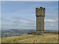
Sutton-in-Craven - Lund's Tower
Lund's Tower [or Sutton Pinnacle] is a folly at the east end of Earl Crag. It was built possibly in commemoration of the 1887 Golden Jubilee for Queen Victoria. The tower is 36 feet in height with a spiral staircase inside.
www.suttonincravenpc.org.uk
Image: © Colin Smith
Taken: 7 Aug 2022
0.24 miles
10
Sutton-in-Craven - Lund's Tower
Lund's Tower [or Sutton Pinnacle] is a folly at the east end of Earl Crag. It was built possibly in commemoration of the 1887 Golden Jubilee for Queen Victoria. The tower is 36 feet in height with a spiral staircase inside.
www.suttonincravenpc.org.uk
Image: © Colin Smith
Taken: 7 Aug 2022
0.24 miles