IMAGES TAKEN NEAR TO
Craven Court, KEIGHLEY, BD20 0HF
Introduction
This page details the photographs taken nearby to Craven Court, BD20 0HF by members of the Geograph project.
The Geograph project started in 2005 with the aim of publishing, organising and preserving representative images for every square kilometre of Great Britain, Ireland and the Isle of Man.

There are currently over 7.5m images from over14,400 individuals and you can help contribute to the project by visiting https://www.geograph.org.uk
Image Map
Images are licensed for reuse under creativecommons.org/licenses/by-sa/2.0
Notes
- Clicking on the map will re-center to the selected point.
- The higher the marker number, the further away the image location is from the centre of the postcode.
Image Listing (180 Images Found)
Images are licensed for reuse under creativecommons.org/licenses/by-sa/2.0
Image
Details
Distance
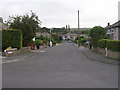
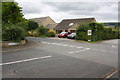
3

New Footpath in Silsden
The picture is taken on the Middleway Meadows new housing development at the top of daisy hill.. Until about 12 months ago this was a green field site.
Image: © David Grimshaw
Taken: 16 Apr 2016
0.05 miles


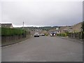
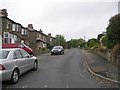
7
Junctions of Hawber Cote Lane and Wayside Mews with Banklands Lane
Image: © Roger Templeman
Taken: 30 Jul 2016
0.08 miles
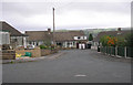
9
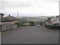
Daisy Hill - viewed from Craven Drive
Image: © Betty Longbottom
Taken: 29 Sep 2009
0.08 miles