IMAGES TAKEN NEAR TO
Avondale Road, SHIPLEY, BD18 4QX
Introduction
This page details the photographs taken nearby to Avondale Road, BD18 4QX by members of the Geograph project.
The Geograph project started in 2005 with the aim of publishing, organising and preserving representative images for every square kilometre of Great Britain, Ireland and the Isle of Man.

There are currently over 7.5m images from over14,400 individuals and you can help contribute to the project by visiting https://www.geograph.org.uk
Image Map (Loading...)


Getting Data...Please wait
Leaflet Map data © OpenStreetMap
Images are licensed for reuse under creativecommons.org/licenses/by-sa/2.0
Notes
- Clicking on the map will re-center to the selected point.
- The higher the marker number, the further away the image location is from the centre of the postcode.
Image Listing (61 Images Found)
Images are licensed for reuse under creativecommons.org/licenses/by-sa/2.0
Image
Details
Distance
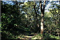
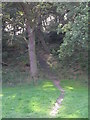
4
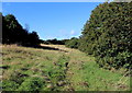
Northcliffe Park
Section of open ground between the woods above Avondale Road and Northcliffe Golf Course - south of Shipley.
Image: © Chris Heaton
Taken: 1 Sep 2014
0.09 miles
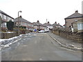
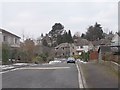
7
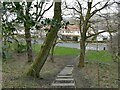
Bottom of steps to Avondale Road
The long flight of steps links the top of Northcliffe Park to the housing estate below.
Image: © Stephen Craven
Taken: 26 Feb 2022
0.11 miles
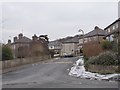
10
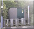
Electricity Substation No 771 - Avondale Road
Image: © Betty Longbottom
Taken: 26 Sep 2011
0.12 miles