IMAGES TAKEN NEAR TO
Titus Street, SHIPLEY, BD18 4LT
Introduction
This page details the photographs taken nearby to Titus Street, BD18 4LT by members of the Geograph project.
The Geograph project started in 2005 with the aim of publishing, organising and preserving representative images for every square kilometre of Great Britain, Ireland and the Isle of Man.

There are currently over 7.5m images from over14,400 individuals and you can help contribute to the project by visiting https://www.geograph.org.uk
Image Map
Images are licensed for reuse under creativecommons.org/licenses/by-sa/2.0
Notes
- Clicking on the map will re-center to the selected point.
- The higher the marker number, the further away the image location is from the centre of the postcode.
Image Listing (951 Images Found)
Images are licensed for reuse under creativecommons.org/licenses/by-sa/2.0
Image
Details
Distance
1
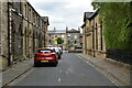
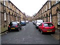
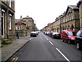
Higher School St
Grade II listed terrace.
Image: © N Chadwick
Taken: 5 May 2019
0.01 miles
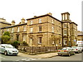
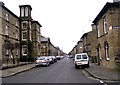
5
Constance Street - Upper Ada Street
Image: © Betty Longbottom
Taken: 20 Dec 2008
0.02 miles
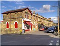
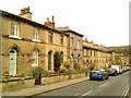
10
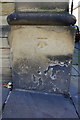
Benchmark on #15 Victoria Road
Ordnance Survey cut mark benchmark described on the Bench Mark Database at http://www.bench-marks.org.uk/bm40637
Image: © Roger Templeman
Taken: 30 Aug 2014
0.02 miles