IMAGES TAKEN NEAR TO
West Way, SHIPLEY, BD18 4HW
Introduction
This page details the photographs taken nearby to West Way, BD18 4HW by members of the Geograph project.
The Geograph project started in 2005 with the aim of publishing, organising and preserving representative images for every square kilometre of Great Britain, Ireland and the Isle of Man.

There are currently over 7.5m images from over14,400 individuals and you can help contribute to the project by visiting https://www.geograph.org.uk
Image Map
Images are licensed for reuse under creativecommons.org/licenses/by-sa/2.0
Notes
- Clicking on the map will re-center to the selected point.
- The higher the marker number, the further away the image location is from the centre of the postcode.
Image Listing (72 Images Found)
Images are licensed for reuse under creativecommons.org/licenses/by-sa/2.0
Image
Details
Distance
5
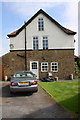
#23 Nab Wood Drive
There is an OS benchmark Image near the right hand corner of the house
Image: © Roger Templeman
Taken: 16 Jun 2015
0.08 miles
6
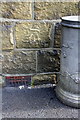
Benchmark on #23 Nab Wood Drive
Ordnance Survey cut mark benchmark described on the Bench Mark Database at http://www.bench-marks.org.uk/bm68720
Image: © Roger Templeman
Taken: 16 Jun 2015
0.08 miles
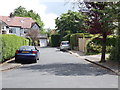
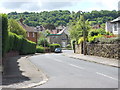
8
Nab Wood Drive - viewed from Ashfield Road
Image: © Betty Longbottom
Taken: 8 Feb 2012
0.09 miles