IMAGES TAKEN NEAR TO
Hirst Mill Crescent, SHIPLEY, BD18 4DA
Introduction
This page details the photographs taken nearby to Hirst Mill Crescent, BD18 4DA by members of the Geograph project.
The Geograph project started in 2005 with the aim of publishing, organising and preserving representative images for every square kilometre of Great Britain, Ireland and the Isle of Man.

There are currently over 7.5m images from over14,400 individuals and you can help contribute to the project by visiting https://www.geograph.org.uk
Image Map
Images are licensed for reuse under creativecommons.org/licenses/by-sa/2.0
Notes
- Clicking on the map will re-center to the selected point.
- The higher the marker number, the further away the image location is from the centre of the postcode.
Image Listing (175 Images Found)
Images are licensed for reuse under creativecommons.org/licenses/by-sa/2.0
Image
Details
Distance
1
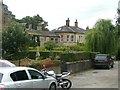
Hirst House, Hirst Mill Crescent, Saltaire
The former mill-owner's house is attached to the mill to the right and some cottages to the left.
Image: © Humphrey Bolton
Taken: 29 Aug 2011
0.00 miles
2
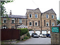
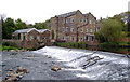
The former Hirst Mill
The mill building has been converted to housing but there is still a ghost sign reading "The Beaver Spring Bed" which perhaps shows an industrial use after it ceased to be a water mill. See Image for a view from across the river.
Image: © Stephen Craven
Taken: 19 Aug 2018
0.01 miles
3
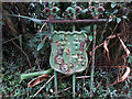
Unusual fire point sign on Hirst Lane
I have not worked out what HL stood for but see Image
Image: © Stephen Craven
Taken: 19 Aug 2018
0.01 miles
4
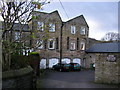
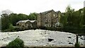
Hirst Mill
Now converted into apartments.
Image: © Stephen Armstrong
Taken: 15 Nov 2009
0.02 miles
5
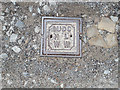
Fire hydrant cover on Hirst Lane
This is the hydrant to which Image refers. SUDC will be Shipley Urban District Council (no longer extant); WW = Water Works, but I haven't worked out what HL stands for.
Image: © Stephen Craven
Taken: 19 Aug 2018
0.02 miles
8
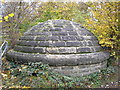
Stone Igloo
This building probably houses pumping gear for a nearby sewage pipe which crosses the River Aire at this point.
Image: © John Illingworth
Taken: 15 Nov 2006
0.03 miles
9
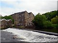
Hirst Mill and Hirst Weir
There is a long history of water mills on this section of the River Aire, and the earliest one on this site existed before 1635. The buildings you can see here look as though they were built in the late 19th century.
Image: © Rich Tea
Taken: 28 May 2009
0.03 miles
10
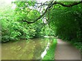
Leeds & Liverpool Canal
Just west of Hirst Lock, heading towards Dowley Gap.
Image: © Rich Tea
Taken: 28 May 2009
0.03 miles