IMAGES TAKEN NEAR TO
Fountain Way, SHIPLEY, BD18 2NF
Introduction
This page details the photographs taken nearby to Fountain Way, BD18 2NF by members of the Geograph project.
The Geograph project started in 2005 with the aim of publishing, organising and preserving representative images for every square kilometre of Great Britain, Ireland and the Isle of Man.

There are currently over 7.5m images from over14,400 individuals and you can help contribute to the project by visiting https://www.geograph.org.uk
Image Map (Loading...)


Getting Data...Please wait
Leaflet Map data © OpenStreetMap
Images are licensed for reuse under creativecommons.org/licenses/by-sa/2.0
Notes
- Clicking on the map will re-center to the selected point.
- The higher the marker number, the further away the image location is from the centre of the postcode.
Image Listing (207 Images Found)
Images are licensed for reuse under creativecommons.org/licenses/by-sa/2.0
Image
Details
Distance

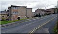
2
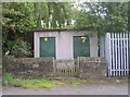
Electricity Substation No 255 - Hall Lane
Image: © Betty Longbottom
Taken: 26 Jul 2011
0.04 miles
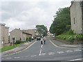
3
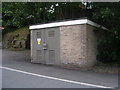
Electricity Substation No 1117 - Hall Lane
Image: © Betty Longbottom
Taken: 26 Jul 2011
0.05 miles
4
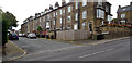
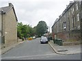
Fountain Way, Shipley
Carr Lane crosses the foreground of the photo.
Image: © habiloid
Taken: 24 Oct 2020
0.05 miles
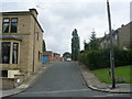
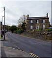
10

#14 Carr Lane, and entrance steps to #16
There is an OS benchmark Image at the base of the wall below the junction of hedges
Image: © Roger Templeman
Taken: 26 May 2017
0.06 miles