IMAGES TAKEN NEAR TO
Crag Road, SHIPLEY, BD18 2EQ
Introduction
This page details the photographs taken nearby to Crag Road, BD18 2EQ by members of the Geograph project.
The Geograph project started in 2005 with the aim of publishing, organising and preserving representative images for every square kilometre of Great Britain, Ireland and the Isle of Man.

There are currently over 7.5m images from over14,400 individuals and you can help contribute to the project by visiting https://www.geograph.org.uk
Image Map
Images are licensed for reuse under creativecommons.org/licenses/by-sa/2.0
Notes
- Clicking on the map will re-center to the selected point.
- The higher the marker number, the further away the image location is from the centre of the postcode.
Image Listing (148 Images Found)
Images are licensed for reuse under creativecommons.org/licenses/by-sa/2.0
Image
Details
Distance
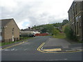
2
Stubbing Way, Windhill
Looking east from the junction with Crag Road.
Image: © michael ely
Taken: 9 May 2008
0.02 miles
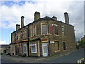
5
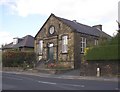
Methodist Chapel, Crag Road, Shipley
This was a Primitive Methodist chapel and was built in 1886.
Image: © Humphrey Bolton
Taken: 10 Sep 2007
0.04 miles
6
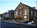
Crag Road Methodist Church, Shipley
Built 1886, as the Primitive Methodist Chapel.
Image: © Stephen Armstrong
Taken: 25 Dec 2009
0.04 miles
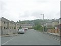
7
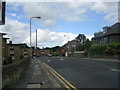
Crag Road - viewed from Poplar Road
Image: © Betty Longbottom
Taken: 15 Aug 2011
0.04 miles
8
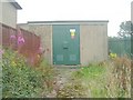
Electricity Substation No 728 - Annie Street
Image: © Betty Longbottom
Taken: 26 Jul 2011
0.05 miles
9
Annie Street - looking towards Owlet Road
Image: © Betty Longbottom
Taken: 26 Jul 2011
0.05 miles