IMAGES TAKEN NEAR TO
Welwyn Avenue, SHIPLEY, BD18 1LL
Introduction
This page details the photographs taken nearby to Welwyn Avenue, BD18 1LL by members of the Geograph project.
The Geograph project started in 2005 with the aim of publishing, organising and preserving representative images for every square kilometre of Great Britain, Ireland and the Isle of Man.

There are currently over 7.5m images from over14,400 individuals and you can help contribute to the project by visiting https://www.geograph.org.uk
Image Map
Images are licensed for reuse under creativecommons.org/licenses/by-sa/2.0
Notes
- Clicking on the map will re-center to the selected point.
- The higher the marker number, the further away the image location is from the centre of the postcode.
Image Listing (64 Images Found)
Images are licensed for reuse under creativecommons.org/licenses/by-sa/2.0
Image
Details
Distance
8
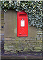
Post box, Westfield Lane, Bradford
This post box can be seen in context in Image
Image: © habiloid
Taken: 15 Feb 2021
0.06 miles
9
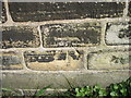
Ordnance Survey Cut Mark
This mark can be found on the wall of the house at the junction of Westfield Lane and All Alone Road.
For more details see : http://www.bench-marks.org.uk/bm41997
Image: © Peter Wood
Taken: 16 Mar 2012
0.06 miles
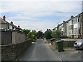
10
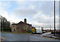
Junction of Westfield Lane and All Alone Road, Bradford
A close up of the post box can be seen in Image
Image: © habiloid
Taken: 15 Feb 2021
0.06 miles