IMAGES TAKEN NEAR TO
St. Anthonys Gardens, SHIPLEY, BD18 1LG
Introduction
This page details the photographs taken nearby to St. Anthonys Gardens, BD18 1LG by members of the Geograph project.
The Geograph project started in 2005 with the aim of publishing, organising and preserving representative images for every square kilometre of Great Britain, Ireland and the Isle of Man.

There are currently over 7.5m images from over14,400 individuals and you can help contribute to the project by visiting https://www.geograph.org.uk
Image Map
Images are licensed for reuse under creativecommons.org/licenses/by-sa/2.0
Notes
- Clicking on the map will re-center to the selected point.
- The higher the marker number, the further away the image location is from the centre of the postcode.
Image Listing (90 Images Found)
Images are licensed for reuse under creativecommons.org/licenses/by-sa/2.0
Image
Details
Distance
3
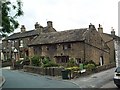
Seventeenth century house, Snowden Road, Wrose
Tucked behind Wrose Road's suburbia are a number of very old houses with the characteristic stone flagged roof. This one bears a date of 1616. Note the difference of height with the neighbouring property.
The building is Grade II listed
Image: © David Spencer
Taken: 7 Jul 2005
0.03 miles