IMAGES TAKEN NEAR TO
Glenaire, SHIPLEY, BD18 1EN
Introduction
This page details the photographs taken nearby to Glenaire, BD18 1EN by members of the Geograph project.
The Geograph project started in 2005 with the aim of publishing, organising and preserving representative images for every square kilometre of Great Britain, Ireland and the Isle of Man.

There are currently over 7.5m images from over14,400 individuals and you can help contribute to the project by visiting https://www.geograph.org.uk
Image Map
Images are licensed for reuse under creativecommons.org/licenses/by-sa/2.0
Notes
- Clicking on the map will re-center to the selected point.
- The higher the marker number, the further away the image location is from the centre of the postcode.
Image Listing (86 Images Found)
Images are licensed for reuse under creativecommons.org/licenses/by-sa/2.0
Image
Details
Distance
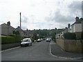
5
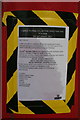
Change to collection times from this postbox
The collection times will be altered for this postbox: Image
Image: © Mark Anderson
Taken: 11 Nov 2008
0.05 miles
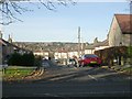
6
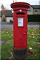
Elizabeth II Postbox, Leeds Road
At the junction with Glenfield. The tape on the side is a notice regarding a change to collection times: Image
Image: © Mark Anderson
Taken: 11 Nov 2008
0.05 miles
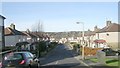

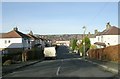
10
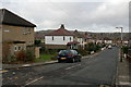
Glenfield, West Royd
Looking along Glenfield from its junction with Leeds Road.
Image: © Mark Anderson
Taken: 11 Nov 2008
0.06 miles