IMAGES TAKEN NEAR TO
Airedale Terrace, SHIPLEY, BD17 7HY
Introduction
This page details the photographs taken nearby to Airedale Terrace, BD17 7HY by members of the Geograph project.
The Geograph project started in 2005 with the aim of publishing, organising and preserving representative images for every square kilometre of Great Britain, Ireland and the Isle of Man.

There are currently over 7.5m images from over14,400 individuals and you can help contribute to the project by visiting https://www.geograph.org.uk
Image Map
Images are licensed for reuse under creativecommons.org/licenses/by-sa/2.0
Notes
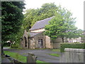
- Clicking on the map will re-center to the selected point.
- The higher the marker number, the further away the image location is from the centre of the postcode.
Image Listing (79 Images Found)
Images are licensed for reuse under creativecommons.org/licenses/by-sa/2.0
Image
Details
Distance
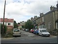
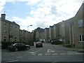
2
Carpets in Charlestown (1)
Three carpet showrooms compete for custom along the A6038 through Charlestown, within this single km square. The first is in a redundant church building: the Wesleyan Methodist Chapel was built in 1870 and closed in 1970, according to a local information board. Compare Image and Image
Image: © Stephen Craven
Taken: 13 Sep 2008
0.03 miles
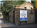
3
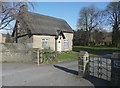
Charlestown Cemetery lodge
Rather a nice foot-gate, and beside it a notice stating that there are Commomwealth war graves in the cemetery.
Image: © Humphrey Bolton
Taken: 16 Apr 2013
0.04 miles
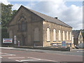
6
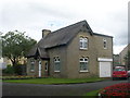
Charlestown Cemetery Lodge - Otley Road
Image: © Betty Longbottom
Taken: 27 Aug 2011
0.05 miles
7
Disused public convenience, Otley Road, Baildon
Photographed to record it before it disappears, as it most likely will before long (though it was said still to be present in 2010). The location is not precise (it could be a few hundred metres either way, on the south side of Otley Road).
Image: © Stephen Craven
Taken: 13 Sep 2008
0.05 miles
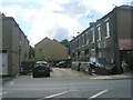
9
Charlestown Cemetery Chapel - Otley Road
Image: © Betty Longbottom
Taken: 27 Aug 2011
0.06 miles
10
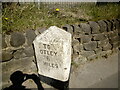
Old milestone
On Otley Road, Charlestown, Baildon just northeast of the railway bridge is this last/first stone on the A6038 which in the turnpike era was part of the Kirkstall, Otley, Shipley Trust. It is about 10 years since it was last painted by a member of the Baildon Local History Society and has stood up well to traffic fumes and bad weather. The left face is inscribed TO/BRADFORD/4/MILES. This stone and the next one Otley 5 have pyramidal tops whereas all other remaining stones from the turnpike trust on this road and the A65 north from Kirkstall have flat tops.
Image: © Mike Sloan
Taken: 19 Apr 2021
0.06 miles