IMAGES TAKEN NEAR TO
Fred Atkinson Way, SHIPLEY, BD17 7HE
Introduction
This page details the photographs taken nearby to Fred Atkinson Way, BD17 7HE by members of the Geograph project.
The Geograph project started in 2005 with the aim of publishing, organising and preserving representative images for every square kilometre of Great Britain, Ireland and the Isle of Man.

There are currently over 7.5m images from over14,400 individuals and you can help contribute to the project by visiting https://www.geograph.org.uk
Image Map
Images are licensed for reuse under creativecommons.org/licenses/by-sa/2.0
Notes
- Clicking on the map will re-center to the selected point.
- The higher the marker number, the further away the image location is from the centre of the postcode.
Image Listing (133 Images Found)
Images are licensed for reuse under creativecommons.org/licenses/by-sa/2.0
Image
Details
Distance
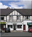
3
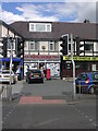
Happy House Chinese Takeaway - Otley Road
Image: © Betty Longbottom
Taken: 27 Aug 2011
0.03 miles
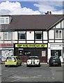
4
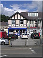
M.B. Trading Discount Tools - Otley Road
Image: © Betty Longbottom
Taken: 27 Aug 2011
0.03 miles
5
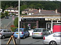
Hope's News & Off Licence - Otley Road
Image: © Betty Longbottom
Taken: 27 Aug 2011
0.03 miles
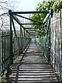
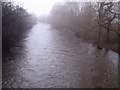
7
![The River Aire, from the footbridge off Dockfield Road [2]](https://s1.geograph.org.uk/geophotos/06/18/01/6180117_1f26c620_120x120.jpg)
The River Aire, from the footbridge off Dockfield Road [2]
Looking upstream [locally south-west].
Image: © Christine Johnstone
Taken: 24 May 2019
0.04 miles
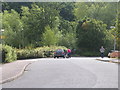
9
The River Aire at Shipley
Looking south-west from the footbridge between Dockfield Road and Otley Road.
Image: © Stephen Armstrong
Taken: 2 Dec 2009
0.05 miles