IMAGES TAKEN NEAR TO
Woodlands, Roundwood Road, SHIPLEY, BD17 6SP
Introduction
This page details the photographs taken nearby to Woodlands, Roundwood Road, BD17 6SP by members of the Geograph project.
The Geograph project started in 2005 with the aim of publishing, organising and preserving representative images for every square kilometre of Great Britain, Ireland and the Isle of Man.

There are currently over 7.5m images from over14,400 individuals and you can help contribute to the project by visiting https://www.geograph.org.uk
Image Map
Images are licensed for reuse under creativecommons.org/licenses/by-sa/2.0
Notes
- Clicking on the map will re-center to the selected point.
- The higher the marker number, the further away the image location is from the centre of the postcode.
Image Listing (77 Images Found)
Images are licensed for reuse under creativecommons.org/licenses/by-sa/2.0
Image
Details
Distance
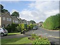
2
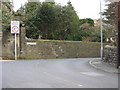
Roundwood Road
Near to the junction of Silson Lane and Roundwood Road
Image: © Chris Barber
Taken: 2 Mar 2008
0.05 miles
3
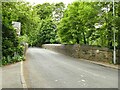
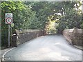
Roundwood Road bridge
The bridge crosses the Ilkley to Shipley railway line.
Image: © Stephen Craven
Taken: 13 Jun 2021
0.07 miles
4
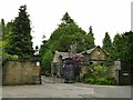
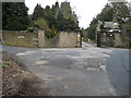
Entrance to Woodlands, Roundwood Road
The lodge and gateway are dated 1899 and grade II listed (list entry 1314251).
Image: © Stephen Craven
Taken: 13 Jun 2021
0.07 miles
5
Woodlands
The entrance to "Woodlands" at the junction of Silson Lane and Roundwood Road
Image: © Chris Barber
Taken: 2 Mar 2008
0.07 miles
7
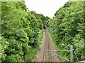
Railway north-east of Roundwood Road
The single-track line between Shipley and Guiseley. Baildon tunnel is just visible.
Image: © Stephen Craven
Taken: 13 Jun 2021
0.07 miles
8
Railway bridge, Station Road
Road bridge above the Shipley to Guiseley single line. The disfiguring coping stones were added when the line was electrified.
Image: © David Spencer
Taken: 12 Jul 2005
0.08 miles
10
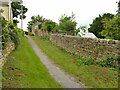
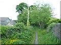
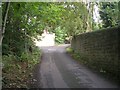
Upper part of Silson Lane
This top part of the lane is closed to motor traffic but is a public footpath.
Image: © Stephen Craven
Taken: 13 Jun 2021
0.09 miles