IMAGES TAKEN NEAR TO
Welwyn Drive, SHIPLEY, BD17 6PH
Introduction
This page details the photographs taken nearby to Welwyn Drive, BD17 6PH by members of the Geograph project.
The Geograph project started in 2005 with the aim of publishing, organising and preserving representative images for every square kilometre of Great Britain, Ireland and the Isle of Man.

There are currently over 7.5m images from over14,400 individuals and you can help contribute to the project by visiting https://www.geograph.org.uk
Image Map
Images are licensed for reuse under creativecommons.org/licenses/by-sa/2.0
Notes
- Clicking on the map will re-center to the selected point.
- The higher the marker number, the further away the image location is from the centre of the postcode.
Image Listing (89 Images Found)
Images are licensed for reuse under creativecommons.org/licenses/by-sa/2.0
Image
Details
Distance
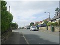
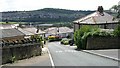
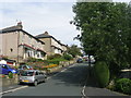
1
Welwyn Drive - looking towards Maude Avenue
Image: © Betty Longbottom
Taken: 2 Sep 2011
0.03 miles
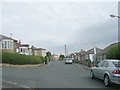
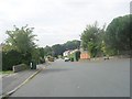
2
Maude Avenue - looking towards Baildon Road
Image: © Betty Longbottom
Taken: 2 Sep 2011
0.04 miles
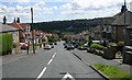
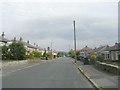
8
St Aidan's Road - viewed from Thornmead Road
Image: © Betty Longbottom
Taken: 2 Sep 2011
0.09 miles
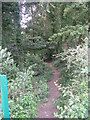
9
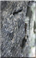
Benchmark on wall of Baildon Road
This Ordnance Survey cut mark benchmark is difficult to see and photograph as it has had a green BT cabinet installed in front of it. It and neighbouring marks are described on the Bench Mark Database at http://www.bench-marks.org.uk/bm43307
Image: © Roger Templeman
Taken: 1 Jun 2012
0.09 miles