IMAGES TAKEN NEAR TO
Moorfield Drive, SHIPLEY, BD17 6LL
Introduction
This page details the photographs taken nearby to Moorfield Drive, BD17 6LL by members of the Geograph project.
The Geograph project started in 2005 with the aim of publishing, organising and preserving representative images for every square kilometre of Great Britain, Ireland and the Isle of Man.

There are currently over 7.5m images from over14,400 individuals and you can help contribute to the project by visiting https://www.geograph.org.uk
Image Map
Images are licensed for reuse under creativecommons.org/licenses/by-sa/2.0
Notes
- Clicking on the map will re-center to the selected point.
- The higher the marker number, the further away the image location is from the centre of the postcode.
Image Listing (84 Images Found)
Images are licensed for reuse under creativecommons.org/licenses/by-sa/2.0
Image
Details
Distance
1
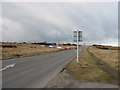
Hawksworth Road, Baildon
On the edge of Baildon Moor, looking north. The queue of cars are waiting to pull out from Bingley Road.
Image: © Stephen Armstrong
Taken: 14 Mar 2010
0.10 miles
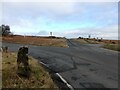
2

Hawksworth Road - Over the Moors & Far Away!
Image: © Betty Longbottom
Taken: 25 Feb 2009
0.11 miles
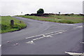
3
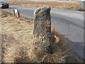
Road Junction on Baildon Moor
This is the junction of Hawksworth Road (straight ahead) & Bingley Road (off left). The stone post has a very damaged OS Cut Benchmark on it, where the light patch is.
Image: © Stephen Armstrong
Taken: 2 Mar 2019
0.11 miles
4
Bingley Road/Hawksworth Road junction
There is an OS benchmark Image on the standing stone at the junction
Image: © Roger Templeman
Taken: 1 Jun 2012
0.11 miles
5
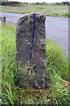
Benchmarked stone at Bingley Road junction
Ordnance Survey cut mark benchmark described on the Bench Mark Database at http://www.bench-marks.org.uk/bm43316
Image: © Roger Templeman
Taken: 1 Jun 2012
0.11 miles

7
Cancelled benchmark north of Baildon
The benchmark is shown on OS maps (at least) 1908 to 1961
Image: © John Slater
Taken: 5 Apr 2013
0.12 miles
8
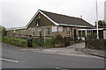
The Shroggs Club, Moorgate
There is an OS benchmark Image on the small wall at the entrance to the club
Image: © Roger Templeman
Taken: 1 Jun 2012
0.13 miles
9
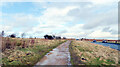
The Millennium Way running alongside Hawksworth Road, Baildon Moor
Image: © habiloid
Taken: 15 Feb 2021
0.13 miles
10
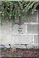
Benchmark on wall at entrance to SHROGGS Club
Ordnance Survey cut mark benchmark described on the Bench Mark Database at http://www.bench-marks.org.uk/bm43315
Image: © Roger Templeman
Taken: 1 Jun 2012
0.14 miles