IMAGES TAKEN NEAR TO
Hoyle Court Road, SHIPLEY, BD17 6EP
Introduction
This page details the photographs taken nearby to Hoyle Court Road, BD17 6EP by members of the Geograph project.
The Geograph project started in 2005 with the aim of publishing, organising and preserving representative images for every square kilometre of Great Britain, Ireland and the Isle of Man.

There are currently over 7.5m images from over14,400 individuals and you can help contribute to the project by visiting https://www.geograph.org.uk
Image Map
Images are licensed for reuse under creativecommons.org/licenses/by-sa/2.0
Notes
- Clicking on the map will re-center to the selected point.
- The higher the marker number, the further away the image location is from the centre of the postcode.
Image Listing (107 Images Found)
Images are licensed for reuse under creativecommons.org/licenses/by-sa/2.0
Image
Details
Distance
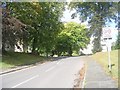
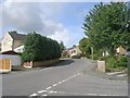
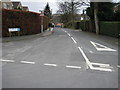
1
Hoyle Court Road - viewed from Hoyle Court Drive
Image: © Betty Longbottom
Taken: 27 Aug 2011
0.04 miles
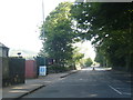
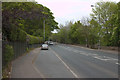
2
Hoyle Court Road - viewed from Hoyle Court Drive
Image: © Betty Longbottom
Taken: 27 Aug 2011
0.05 miles
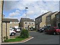
4
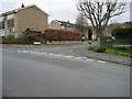
Hoyle Court Avenue
The junction of Hoyle Court Avenue with Hoyle Court Road
Image: © Chris Barber
Taken: 2 Mar 2008
0.08 miles
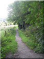
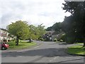
6
Kirklands Lane
Stood in the middle of Hoyle Court Road looking down Kirklands Lane. The new, bright red roof of St James' Church can be seen in the centre of the shot
Image: © Chris Barber
Taken: 2 Mar 2008
0.09 miles